Wow, it’s been quite a while since my last post, hasn’t it? Sorry about that. I’ve missed you too.
In my defence, I’ve been busy adjusting to life in Groningen in the Netherlands – yes, I’ve moved to one of those places which people like to go on and on about because it’s great for cycling.
And Groningen really is great for cycling – mostly.
While the city and surrounding areas are generally very good or even excellent for cycling, there are many baffling gaps, neglected corners, and dangerous designs.
So after spending years praising many good bits of infrastructure in this country, I think I’ve earned the right to complain about some of the bad bits, the exceptions to the cycling wonderland that is the Netherlands.
So let’s start with Damsterplein, shall we?
Damsterplein: I think that’s Dutch for “disappointment”
I first experienced Damsterplein completely by accident, riding around the city when we first arrived, in the spirit of happy exploration. I was stunned to find such a large, busy road without any good cycling infrastructure – only intermittent, legal-to-drive-in “advisory” cycle lanes, which disappear at bus stops so that buses can pull in.
Since that first visit I’ve avoided using the road as much as possible. I cycled through there recently, to take photos for this blog post, now in the spirit of brave investigation. And yet although I’ve only ridden here maybe half a dozen times, I’ve had an unpleasant experience every single time, usually caused by having to pull out into a stream of moving motor traffic in order to overtake a bus legitimately waiting at a bus stop, or a car parked in the cycle lane.
Every. Single. Time. Now you can see why I avoid riding there.
So here’s a few pictures, some which I took myself, and some from Google Streetview to prove that I’m not cherry-picking rare situations. Avid cycling blog readers may recognise Damsterplein, as David Hembrow has mentioned it in a couple of blog posts.
Luckily for this guy, the Streetview car was hanging back (Source: Google Maps)

Does this look like an “8 to 80, all-abilities” cycling environment to you? (Source: Google Maps)

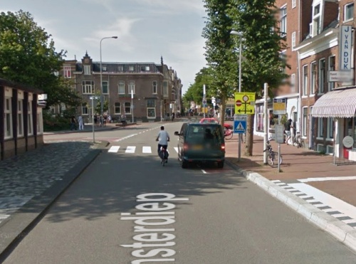
It’ll be fine, he’s just nipping in to the shop for a few minutes. Don’t worry about the bus that’s about to overtake you. (Source: Google Maps)

Motor vehicles parked three-wide, one lane of moving motor vehicles, and no actual space for cycling here on the southern side of Damsterplein.
After I took this photo, the driver of the car behind me decided to overtake as I was passing this parked car. I will not cycle here again.
And if you thought the cycling “infrastructure” here looked crap, then the footways aren’t much better. All the cars in the photos above which appear to be parked on the footway are in fact parked legally. Here’s an unusually car-free section:

The dark line marks the official edge of the parking space, leaving just a metre or so for walking – and that’s assuming that the vehicle is parked perfectly within the space. (Source: Google Maps)
This arrangement is pretty crap for walking. It’s not much fun finding a van mounting the kerb toward you, and as
a recent case in the UK tragically showed, having motor vehicles mounting the footway can have lethal consequences. Could a young child be expected to know that the black line denotes a parking space into which a motor vehicle may be driven?
This footway parking design also means that cars and vans must be driven across the cycle lane in order to access the parking spaces, which creates delay and danger for people cycling – and this also means that the cycle lane is now in the door zone.
I also worry that this kind of design for parking essentially legitimises use of the footway for other things (rather like the “shared footway” designs in the UK legitimise pavement cycling). It conditions people into parking on the footway, not just here but in general. It says “don’t worry if there’s no parking space, just stick the van on the footway, it’ll be reet for a bit.”
And all this motor-centric (and anti-cycling and anti-walking) design exists despite there being acres of space here in which to get things right. See how much room for manoeuvre the driver of this car has within the single humongous traffic lane:

Narrow, medieval streets?
A sea of asphalt, about three cars wide, and yet there’s no space for proper cycling infrastructure? I’m calling bullshit on that one.
(Also, how about those tyre marks? Do they suggest safe and careful driving? What you can’t see on this cropped photo are the motor vehicle tyre marks along the cycle lane…)
Cycling backwards through time
Anyway, I was going to end my post there – these “Crap of the Week” posts are meant to be brief – but while looking at old Streetview and aerial photos, I learned a little bit of recent history about the place, and my distaste for the current layout grew deeper: it’s brand new.
Well, almost – the current layout was built between 2008 and 2010 as far as I can tell. Here’s how the street looked 10 years ago:

Here’s the western end (closest to the city centre) in 2007. None of the current square exists, but there is a cycleway on one side of the road. (Source: Google Earth)

And here’s the eastern end. Note that a single-lane road becomes four lanes at the junction. (Source: Google Earth)
So heading west into the city, it’s always been pretty crap – the cycleway suddenly ends at the junction with Oostersingel, and people were (and still are) expected to cycle around a jumble of parked cars and stopped buses. That hasn’t changed.
But heading east, out of the city, the cycling experience has become so much poorer. In 2007, after crossing the bridge over the canal, a protected cycleway begun almost straight away and took you safely all the way to the huge junction to the east. That’s now gone.
Overall, however, the square that is now Damsterplein looked like a pretty dismal place, essentially a large car park. So the city decided to spruce things up by creating a new public square (a fine idea!) underneath which would be a massive multi-storey subterranean car park.
(Now this car park is interesting in itself. It’s often said that for a city to be cycling-friendly, it must be hostile to driving. And yet Damsterplein isn’t the only brand-new underground car park in Groningen. The city must be spending millions of Euros on these things, which doesn’t seem like the actions of a body that wishes to discourage people from driving into the city.)
So, the whole area – the entire massive space between the buildings – was being redeveloped. Every centimetre would be dug up and replaced. This was a blank canvas, on which millions of Euros would be spent.

Damsterplein in 2008. All of this ground was about to be torn up and replaced. (Source: Google Maps)
Surely with such a large-scale project, the citizens of Groningen could expect some top-notch cycling infrastructure for their money?
For at least two years all vehicle access had been severed – enough time for people to adjust their travel patterns and become accustomed to the idea that Damsterplein wasn’t a through-route for motors. Surely a golden opportunity to introduce a pleasant, motor-free square on the edge of the city centre.
Here’s the same view today:

Damsterplein today. Seven lanes of motor traffic – beautiful. (Source: Google Maps)
Now the seven lanes of motor traffic you see here aren’t as bad as they look, as at this end of Damsterplein there
are proper separated cycleways – but the size of this junction suggests that the amount of motor traffic circulating around Damsterplein itself is too large for cycling to be mixed in with it.
Instead of the peaceful motor-free or very-low-traffic square that was surely possible, Damsterplein is instead surrounded by rumbling engines on all sides.
I’m staggered that with all the changes that have gone on here (and since completion there have been retrofitted tweaks for buses and for car park traffic) the designers decided not only to rebuild the old unprotected cycle lane on the city-bound side of Damsterplein, but also to copy that dangerous design across to the outbound side too.
This is a city which claims a 60% modal share for cycling (which isn’t actually true, but we’ll come to that another time) and yet even here, cycling infrastructure is chipped away at and downgraded in favour of motor vehicles.
I could forgive crap infrastructure a little bit when it’s old and in need of replacement. After all, Rome wasn’t built in a day. But when something is just a few years old – designed and built with wilful ignorance of all that we know about good cycling infrastructure, and the dangers of mixing heavy motor traffic with cycling – it’s completely unforgivable.


 The Alternative Department for Transport is written by, and the personal opinion of,