Monthly Archives: May 2012

A Tale of Two Streets

What is the difference between a street and a road?

Roads carry traffic from one place to another. When you make a journey by car, you should be on roads almost the entire time, the exceptions being when you set off from home, and when you arrive at your destination.

Streets are where people live, and the only traffic on them should be traffic that needs to be there – residents, visitors, deliveries.

So why is the phrase “rat run” so familiar in the UK?

A rat run is a street that is being used as a through-road. Most streets in the UK can be used like this, which is why children don’t play out in the street any more, as it’s highly likely that someone who has no business in the neighbourhood will be using the street as a short cut. This is the standard UK road design – but why?

Near my home there are two streets, and they’re very similar:

  • They are both residential streets (though one has many shops on too).
  • There are main roads to the North, South, and East.
  • They are connected directly to the road to the South.
  • They are connected the road road the East, very near to the junction with the road to the North.
  • They have a one-way street connecting them to the road to the East.

One of them is great to walk or ride along, but the other one can be horrible. One of them has hardly any traffic, the other is full of speeding taxis, motorbikes and vans.

Here’s why:

Hercules Road in London SE1, showing bad design which encourages rat-running

There is no restriction on traffic through the street here

As there is no restriction on traffic passing through the street, traffic heading from the North to the South-West (or vice-versa) can skip one set of traffic lights by using it as a rat-run, instead of keeping to the main through-roads.

Lower Marsh in London SE1, showing design which prevents rat-running.

Better design makes rat-running impossible, and the street is pleasant as a result

On this street just around the corner (I’ve kept the same layout for comparison) you can see that rat-running is impossible here, it doesn’t help you to use the street instead of the road. As a result, only vehicles who have reason to visit the street will do so.

The streets in question are Hercules Road and Lower Marsh, both in London SE1. Okay, so I kept the same layout for both streets, they’re not really quite as similar as that – Hercules Road has three one-way streets connecting to the West, whereas Lower Marsh has none any more, due to Waterloo station –  but they are very much the same in most important aspects.

Lower Marsh is pleasant to walk down, ride down, or even drive down, if you must! On how many streets in central London can a cat sit and wash?

A cat washing itself on Lower Marsh

Now this is what I call “shared space”!

Whereas Hercules Road isn’t even safe for fast cyclists, due to the aggressive rat-running, and also this awful pinch-point:

A nasty pinch-point on the rat run that is Hercules Road

I didn’t intentionally set out to get photos of taxis here, but they are very numerous! (Hercules Road is mainly residential, though the railway arches at the South-West end, seen in the background, are used as business units It’s also extremely wide at the Southern end.)

So here we have an example of good design, and bad design. Lower Marsh works, and there is no reason for Hercules Road to be a through-route for motor vehicles. Who do I get in touch with to look at this?

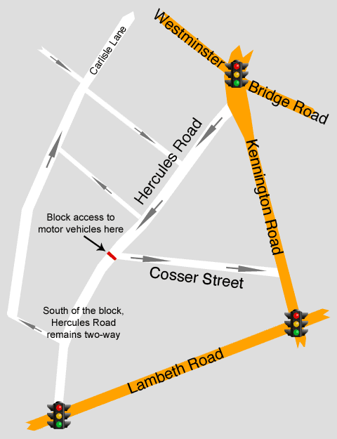
UPDATE, 29th of May 2012: I’ve been thinking about the options for Hercules Road (I do actually have that much time on my hands!) and a Lower Marsh-style solution won’t work, as it will still allow traffic heading North to rat-run around the traffic lights at the junction of Kennington Road and Lambeth Road. There’s tons of options, but I think the main point should be to remove the desire to use a street as a thoroughfare – a street should be a destination, not part of a route.

So, here’s one possible solution (I’ve added in a few more roads on this plan – all the one-way restrictions on these streets are already there):

Hercules Road, suggested motor traffic reduction scheme. Blocking motor traffic just south of the junction with Cosser Street will solve this.

Aah, I can see the cats sitting safely in the road now!

With this plan, the southern part of Hercules Road remains two-way. This is useful for the business units who rent space beneath the railway on the west side. (Luckily for the catering company which faces Cosser Street, they have a driveway on each side of the barrier!)

I’m not sure whether the top half of Hercules Road needs making one-way or not (probably does), but I’m certain that putting that motor vehicle restriction in place will remove the desire for using the street as a rat-run. Residents and businesses still have access, but the ability to skip the lights has gone.

I don’t know how much a few signs, a lick of paint and a concrete kerb cost, but I dare say it’s well within the budget of Lambeth Council to make Hercules Road into a street fit for those who live there.

4 Comments

Filed under Uncategorized

The National Cycle Network in London

If the hot air generated by successive UK governments talking about cycling could somehow be harnessed, then we could stop importing gas. They keep on talking about increasing bike usage, and yet cycling rates in the UK have stagnated since the 1970s. This might have something to do with our road and street design!

According to the cyclists’ group CTC, the National Cycle Network “is a comprehensive network of safe and attractive routes to cycle.

Perhaps that should be changed to “a patchwork of theoretical routes which sometimes go near where you want to go.”

While I acknowledge that the CTC aren’t responsible for the NCN, and that the quality of NCN routes in central London may not be typical of the UK as a whole, here are three examples of the safe and attractive NCN Route 4 in my area:

NCN Route 4 at junction of Belvedere Road and Chicheley Street, London SE1, where there is a plastic chain blocking the cycle route.

London’s cycling revolution?

Heading North on Belvedere Road near the London Eye, the citizen who has fallen for the current government hype about cycling will come across the lovely arrangement above. Is this really meant to encourage people to start riding a bike?

NCN4, on Park Street near the Tate Modern gallery. The cycle lane is blocked by roadworks, with not even the usual "Cyclists Dismount" sign!

I assume Boris Johnson never comes this way.

On Park Street near the Tate Modern gallery, the cycle lane is blocked by roadworks, with not even the usual “Cyclists Dismount” sign! It shows the contempt with which people on bikes are held in London that there is no warning, diversion or provision for bike riders here – not that I could see, anyway.

NCN route 4, on Clink Street. The route has been narrowed, and is full of pedestrians.

NCN4 on Clink Street. Safe, convenient and attractive, or just treacherous, narrow and difficult?

This part of NCN4 passes through a “shared space” zone. These shared space areas seem to me to be unfair to everyone – especially people on foot or riding bikes. Nobody ever seems to know what’s going on in them.

Does the map of NCN4 below look convenient to you, or does the main road look more direct?

NCN route 4 along the South Bank in London. It's not very convenient!

NCN Route 4 winds and twists its way around the South Bank, while the roads smoothly glide by.


The NCN seems to be endorsed by the DfT, and it’s part of the UK street and road network, so it seems a relevant subject for this blog. I don’t mean to slag off the good people of Sustrans or CTC, but this sort of thing really isn’t going to convince anyone to switch to pedal power.

3 Comments

Filed under Uncategorized

Gary Mason, killed by poor design?

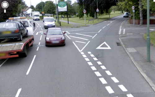
In January 2011, former pro boxer Gary Mason was killed at the junction of Sandy Lane South and Woodcote Road in South London. He was either riding or walking with his bike when he was hit by a van cutting the corner of the junction. (Map here, I recommend you have a look around on Street View to appreciate the awfulness of this junction.)

Sandy Lane South in 2008 on Google Street View, showing dangerous junction design

Who the hell is responsible for this mess?

I would like to ask those responsible for this junction: What the hell is this? Your shitty designs contributed to the death of an innocent man. I don’t know whose fault this is – was the designer in a rush, or were there cost restrictions from above which meant that a lick of paint was the only option? Or were they just following orders – is this what the DfT manual demands? Or is it a legacy design from decades ago, when road standards and traffic levels were lower? Either way, it’s time for those in charge to either sort this out or get a new job, because this won’t do.

With all those design rules and official guidance, with decades of experience and data collected, is this really the best junction design? This seems typical of poor UK road design. There’s tons of space here for a safe junction design, yet here we have this failure instead. Rather than design a safe junction for everyone – cars, vans, people on foot, people on bikes, people with prams, disabled people – we cover a large area with tarmac, slap on some white paint, and hope for the best.

(Furthermore, on a related but separate point, rather than implement residential zones which prevent rat-running and make our streets pleasant for children to play, it seems the UK standard is for all streets to be through-roads to relieve the strain on the main routes. It seems insane to me that any residential streets are used by motor vehicles just passing through. Good road design would make this impossible, or at the very least, slow and undesirable. So, is this junction needed at all? There is another road a little further north called Woodcote Green which provides access to the streets to the east.)

While the driver of the van that hit Mason can’t be excused, poor driving will always occur. How many of us can claim to have 100%,  360º concentration on our driving 100% of the time? The roads should be designed to mitigate mistakes and reduce conflict. UK road design leaves little margin for error, and does little to protect those not encased in the metal shell of a motor vehicle. The real guilty party is successive UK governments who have encouraged us to be dependent on cars and shoddily designed our living space around them moving around as fast as possible, to the detriment of all else.

Maybe the DfT would say that the junction design here follows best practice, that they’ve scientifically worked out the safest way to design a junction, or that mistakes will happen so try not to worry about it too much. Well, if this is the result then something has clearly gone very wrong somewhere.

How the hell did this junction get approved? It’s not as if some passing council worker just decided to get out the Dulux and make it up as he went along. It required a whole slew of people to mess this up. This junction was designed by a technical planner who probably went to university to study this sort of thing. It was approved by his boss at the council’s roads department. It was signed off by the road markings committee.* It was installed by a road painting crew who must wonder why those designing and approving the paint plans get paid so much.

SOMEBODY WAS PAID ACTUAL MONEY TO DESIGN THIS JUNCTION!

The UK is covered in crap designs like this, and it’s not good enough. I hope to be covering many more half-arsed designs as this blog progresses.

UPDATE: I’ve had a fiddle with the photo, and if you’ll excuse the amateurish editing, here’s one design which massively improves the safety at this junction. There’s other options, of course, and I haven’t even looked into cycle paths or pedestrian crossings here, but if the junction had been laid out like this in January 2011, then the van that killed Gary Mason wouldn’t have been able to make the corner-cutting manoeuvre that caused the accident.

Sandy Lane South junction, reworked as two standard junctions for improved safety

Seems obvious to me, but then this might slow someone’s journey by about ten seconds, so it’s obviously no good.

Simply by widening the path, making this into two standard junctions instead of the crazy hotch-potch of markings which are there currently, would make this junction much safer.

* I don’t know the exact procedures that road designs go through before they reach the paint crew, but these things must be designed and approved in a department of more than one person, surely?


Update, 26th October 2012:

Two things:

1. The van driver cut the corner at a speed high enough to kill Gary Mason (who may not have actually been on the bike but may have been pushing it – either way it’s thought that he was either stationary or walking with the bike) and yet the incident was described as a “cycling accident” or “cycle crash” in most news reports. He was hit by a van breaking the rules at a criminally badly designed junction, the bike was pretty irrelevant! It could just as easily be described as a “racial incident” as a “cycling incident”.

2. Eighteen months later, the deadly junction where Gary Mason was killed has still not been re-designed. Is this professional negligence? Corporate manslaughter? Is there really nothing the authorities can do to improve this junction? It sickens me that nothing has changed here. This was an “accident waiting to happen” and while the junction remains this way, it’s waiting to happen again.


6 Comments

Filed under Uncategorized