Tag Archives: City Connect

Another visit to Leeds’ unfinished “Cycle Superhighway” with no end in sight

Note: For all those Evening Post readers who email me to complain about cycling in general – I’m not against cycling, or cycling infrastructure. The reason you spend so long sat in traffic is because Leeds has given people no other option but the car. Leeds needs cycling infrastructure. So the concept behind this scheme is sound – but the execution is very poor, and that’s what I’m criticising here.

Well here we are again, back in Leeds. And it’s the same old story – delayed works, lack of communication, bad design and broken promises. The eastern cycleway – from the city centre, along the A64 York Road, out to the A6120 Ring Road – still isn’t finished, despite several completion dates passing without comment.

It’s difficult to know where to begin when writing about the City Connect project, as there are so many bad points to cover. So maybe I’ll start with one or two good things that I saw, to begin on a positive note.

The good bits

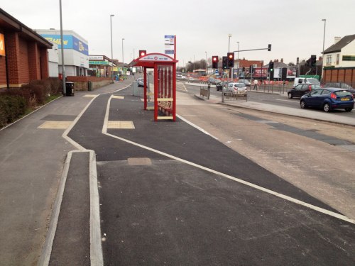
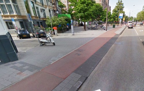
Well firstly, this bus stop bypass isn’t too bad. The cycleway could be wider, especially considering the massive width of the road, but the kerbs are forgiving, and there’s a verge separating it from the road. There are no sharp turns at the bus stop, but I’m not sure about the pedestrian crossing angles, though the difference in surface colour should help.

An overhead view of a cycleway at a bus stop bypass in Leeds

Some sections of kerb are extremely forgiving – maybe even too much, as when the cycleway and footway are both surfaced in the same black asphalt, the difference isn’t clear enough. Really, the cycleway should be a different colour asphalt.

But this is much better than the pseudo-forgiving kerbs used on some other cycleways, which are too high and/or too steep.

A close-up photo of the join of a footway and cycleway in Leeds. The kerb between the two is short, with an angled side. The cycleway is lower than the footway.

And that’s about it. I’m afraid that’s pretty much the extent of the good stuff I saw. (And not all the kerbing is as good as that bit, either.)

Changes, delays and silence

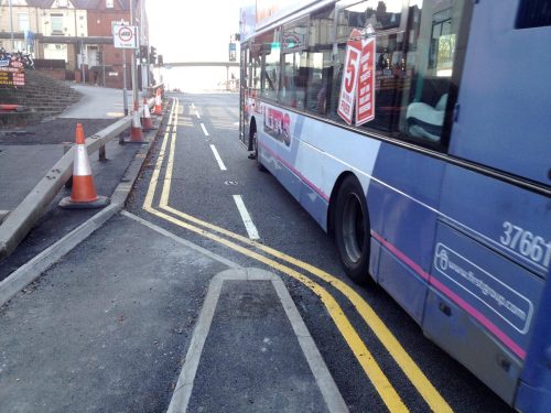
This section of the project was meant to have been finished months ago – last year even, perhaps – I’ve lost track of the number of times that the deadline for opening has been missed. The latest update from City Connect said that the work was to be completed by the end of October – so these photos, taken in early November, should be of the finished article.

Earlier this year City Connect tried to fob us off with a sleight of hand, splitting the route into two parts so that they could declare the project complete in June, despite only the western section – now branded CS1 – being finished. This eastern portion, labelled CS2, remains incomplete.

When I was there at the start of November, it was clear that there are still lots of physical engineering works which haven’t been done, but the solution seems to have been to quickly cover up the gaps with paint so that the City Connect PR machine can pretend it’s finished for now.

Quite unlike the promises of excellent infrastructure made at the start of the project, much of the “Cycle Superhighway” resembles the usual failed excuses for cycle infrastructure which any British cycle campaigner is familiar with: shared use footways, narrow painted lanes on busy roads, fiddly and inconvenient junctions, long waits at multiple toucan crossings, and so on.

It represents business as usual, not the great leap forward it was sold as.

So easy, it’s child’s play

Along the route there are lots of newly-installed banners proclaiming City Connect’s cycle route to be “as easy as riding a bike”, which also feature the logo of something called Child Friendly Leeds. This is a council initiative which aims “to make Leeds a child friendly city” and claims to believe that a “successful city has children and young people at its heart”.

Banner attached to a lamp post. Text on banner reads: CityConnect. Seacroft - Leeds - Bradford. Your journey, as easy as riding a bike. We are child friendly Leeds.

Well, either Child Friendly Leeds is just another attempt by Leeds City Council to whitewash over their business-as-usual policies, or there will be some very angry people who are annoyed that their logo is plastered over infrastructure which is anything but child-friendly.

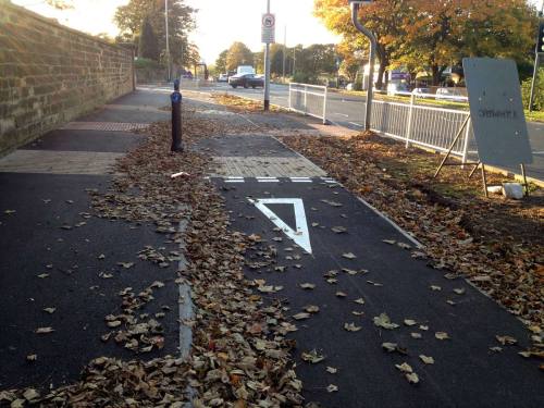
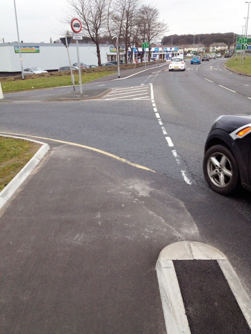
Give way on the cycleway, AKA priority for motoring

One of the first things that caught my attention was that several give way markings have been added on the cycleway, despite promises from City Connect that the cycleway would have priority at side roads.

This is poor design: people using the cycleway should usually have the same priority as those using the road, otherwise it just results in slower journeys.

A bus turns across a cycleway in Leeds, with priority

06-leeds-cycle-superhighway-gives-way-at-side-road-exhibit-d

07-leeds-cycle-superhighway-gives-way-at-side-road-exhibit-e

03-leeds-cycle-superhighway-gives-way-at-side-road-exhibit-a

04-leeds-cycle-superhighway-gives-way-at-side-road-exhibit-b

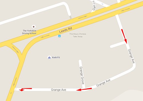
None of this bears any resemblance to the plans that were consulted on, the junction diagrams provided, the agreements with cycling groups, and the reassurances (PDF) offered after the Grange Avenue fiasco that such a junction design would be a rarity.

You’ll notice that on the final photo above, people cycling must give way to traffic from both directions. (In the first four, there is, at least, priority over vehicles exiting the side road.)

But while these give way markings are new, the rot had already set in many months, or even years, ago. The way these junctions were designed, and subsequently installed, it was inevitable that the cycleway would yield to the carriageway. Such junctions with priority squeezed alongside a busy 40mph arterial road aren’t ever going to work safely – hence why painted cycle lanes can also be dangerous, they can lead to the infamous “left hook” collision.

The junctions above should never have been designed like that in the first place. If a cycleway is to cross a side road like this, the cycleway should be set further back from the road, with a raised “continuous footway/cycleway” junction to slow turning vehicles further – which City Connect knew about, as it was included in their junction type diagrams. (Though would this work along a 40mph dual carriageway anyway, or are signals required?)

So while I don’t agree at all with the decision, I can see why someone eventually opted to paint in give way markings at these junctions – not that that makes them safe, but that it ticks a box somewhere, so that the blame for any collision can be placed on the person cycling.

Give way anyway

At some points, there are even give way markings for… no reason at all! The photo below shows the cycleway and footway merging to become shared space at a crossing, but not all crossings are done like this. Sometimes the shared footway starts with a give way marking, sometimes just wheel-grabbing tactile paving slabs.

11 Leeds cycle superhighway - give way at crossing.jpg

Vague crossovers

But like so much of the City Connect project, there’s absolutely no consistency at all. Many of the crossovers (entrances to car parks, petrol stations, etc.), often just metres away from the junctions pictured above, do give priority to the cycleway, although it’s done vaguely with just green paint (no white lines) which does little for visual priority.

08-leeds-cycle-superhighway-york-road-car-park-entrance

09-leeds-cycle-superhighway-york-road-petrol-station-entrance

22-leeds-cycle-superhighway-crossover

If it’s safe at these junctions, then why is it dangerous at the others? And if it’s dangerous at the others, why is it safe here? I know that crossovers and side-roads are technically different, but I doubt many drivers will approach them differently here.

Junctions with cycleway priority

To be fair, the cycleway does have priority at some junctions, but this has often been done incompetently, with unneccesarily vague design…

30-leeds-cycle-superhighway-vague-junction-priority

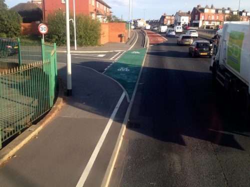
While a flush kerb might have no legal meaning with regards to junction priority, people can still clearly see it, so it’s important for visual priority. Hence, the kerbs which run along either side of the cycleway are good (as they reinforce priority), but the kerbs which cut across the cycleway are bad (because they negate that intended priority). The coloured surface should extend several metres along the cycleway before and after the junction.

…or with sudden, sharp turns.

A cycleway in Leeds crosses a side road with priority

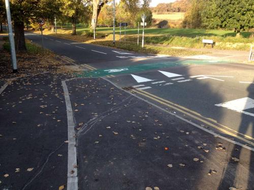
Note how there’s no continuous footway here, and the road surface doesn’t change to a different material. The green surfacing doesn’t extend much beyond the junction itself either, and there’s no line marking the edge of the cycleway, which would give good visual priority.

A side road with cycleway priority on Leeds Cycle Superhighway

Here, any cars turning off using this sliproad (designed for speed) will be right alongside (or just behind) anyone riding on the cycleway, just before they make a sharp right-hand turn across their path. At least the priority is clear, due to the give way markings being right up against the cycleway.

An unfinished side road crossing on Leeds Cycle Superhighway

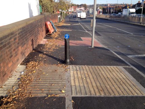
This side road junction is unfinished. But note the tight 90º turns required (we’ve already done two to reach this point). Also note that the kerb cuts across the cycleway, and that the footway is interrupted by the carriageway too.

Furthermore, when the roadworks were done, the kerb line (which cuts across the cycleway for no real reason) wasn’t laid quite flush – there’s a slight drop as the cycleway begins to cross the road, and a slight bump up at the other side.

You can see here where the leaves have gathered against the upstand on the far side of the junction, which anyone cycling along the route must mount as they ride along:

34-leeds-cycle-superhighway-upstand-on-cycleway-with-leaves

In some places, City Connect have covered this up by slopping lots of green paint on there, but it can still be felt, and in some places it causes puddles to form, which will be fun in the winter.

14-leeds-cycle-superhighway-paint-slopped-on-bad-join-at-junction

15-leeds-cycle-superhighway-water-pooling-along-kerb-lip

A sense of abandonment

And at some junctions, there’s nothing at all for cycling. A mixed-use footway simply ends at the junction, as if City Connect simply never existed.

10-leeds-cycle-superhighway-goes-missing

12-leeds-cycle-superhighway-disappears-at-a-very-minor-junction

29-leeds-cycle-superhighway-shared-use-footway-driveway-without-priority

A shared footway (i.e. cycling permitted) crosses a side road on Leeds Cycle Superhighway

This is super, apparently.

Right, said Fred…

Quite often, it feels like the contractors were told just to finish the job as quickly and cheaply as possible, without worrying whether it actually works or not.

In some places, the cycleway vanishes entirely, with stretches of shared-use footway common:

A footway in Leeds where cycling is permitted. About 25% of the width is taken up by telecoms cabinets.

You share with people walking, and with a mobile phone mast and equipment cabinets.

Here, the “Cycle Superhighway” manifests as the amazing piece of infrastructure we’re all familiar with – a white line in the middle of a footway.

Leeds City Council have painted a white line on a footway, and called it a Cycle Superhighway

In this form, it crosses the entrance to a petrol station, before giving up altogether just before the exit. Beyond this point, the cycleway doesn’t even exist as a white line, it simply disappears. Sorry, I mean it Cycle Super-disappears.

Leeds Cycle Superhighway, in the form of a white line on a footway, crosses the entrance to a petrol station before disappearing altogether

In other places, the rush job means that the cycleway becomes an unmarked shared-use footway, which then becomes… a painted lane on the road. Ah, such amazing infrastructure, well worth waiting years for, truly Super!

18-leeds-cycle-superhighway-becomes-a-painted-lane-on-a-fast-busy-road

Even this hasn’t been done well, requiring a double-turn onto a fast, busy road, with nothing but white paint and crossed fingers for protection (the lighter section of kerb-stone is the extent of the dropped area). This whole stretch is utterly unsuitable for anything wider than a bicycle, such as a hand-bike or cargo bike.

Remember, according to Leeds City Council, this is “child friendly” infrastructure – so I’ve taken the opportunity to add the appropriate logo to the next photo.

19-leeds-cycle-superhighway-is-a-narrow-painted-cycle-lane-on-a-busy-road-with-cfl-logo

There’s a motorway-style crash barrier here to protect the traffic lights (presumably), but anyone cycling here will be on the wrong side of it. This probably tells you all you need to know about how much Leeds City Council cares about cycling.

Thrown to the Loiners

This design – rejoining the carriageway at a busy junction – occurs more than once, including on both sides of the major junction with Harehills Road.

On the westbound side, someone has at least had a go at designing a decent transition from cycleway to cycle lane, though such a design has no place at any busy urban crossroads. It’s completely inappropriate to send people cycling into mixed traffic here, a point where they need protection the most.

Leeds Cycle Superhighway suddenly turns into a bike lane at Harehills Road junction

Again, there’s plenty of space here. Why are people cycling sent on the wrong side of a crash barrier, to share time and space with heavy motor traffic at a busy junction? Isn’t this exactly the sort of problem that City Connect was meant to solve? Instead they’ve shrugged their shoulders whenever any difficult decision had to be taken.

Heading eastbound, the situation is even worse – although, of course, as the damn thing still isn’t finished, who knows how it will end up? (If City Connect know, they’re not telling anyone.)

Anyway, this is what I suspect is intended: After avoiding people walking or waiting at this narrow shared-use space at a bus stop…

25-leeds-cycle-superhighway-junction-with-harehills-lane-1-bus-stop

…your handbike-using grandma or trike-riding nephew is then expected to “rejoin the carriageway” here, by use of this dropped kerb…

26-leeds-cycle-superhighway-junction-with-harehills-lane-2-dropped-kerb-cycle-lane

Space is clearly at a premium here. Narrow medieval streets and all that.

…and arrive at this mutant ASL, which certainly won’t be full of stopped vans.

27-leeds-cycle-superhighway-junction-with-harehills-lane-3-bizarre-asl

People cycling along the “Superhighway” will be travelling straight on here, remember – i.e. they’re going the same way as the red car – so they’ll need to watch out for drivers turning left at the speedy 1960s-style slip-road junction.

Again, this is exactly the kind of interaction that City Connect was meant to put an end to. What’s the point in City Connect’s existence if they’re not going to fix junctions like this?

Should they survive, sanctuary beckons as the protected cycleway begins again on the far side of the junction (though note the kerb, cutting across the entrance to the cycleway at an angle, which is there for no reason other than to pose a hazard in wet weather).

28-leeds-cycle-superhighway-junction-with-harehills-lane-4-junction-end

In conclusion: it keeps getting worse!

We were promised a first-class cycleway, but we’ve been misled and ignored constantly. Now we have infrastructure which is a real curate’s egg: whilst some bits are okay, much of it is rotten.

I do feel a little sympathy for the people designing this monstrosity, as it’s been said that Leeds City Council forbade even one centimetre of road space to be taken for cycling infrastructure. If that’s true – and I’ve heard it from many sources – then the project was doomed from the start.

But whatever the reason, the designs used by City Connect have been proven to be unattractive, inconvenient and even deadly many times before, yet we’re expected to be grateful for anything at all. Their interest in this project has clearly already dwindled, and they’re on to the next pot of funding already. There’s no consistency, no accountability, and no reliability.

Despite their claims to be an infrastructure project, City Connect now spend most of their time tweeting about cycle training and lights, and very little effort is spent on discussing infrastructure. This seems to be the norm for lots of UK cycling projects – the hard stuff is too hard and too quantifiable, so instead they fall back on “encouragement and promotion”, despite it being proven to be useless – but then, that’s all that’s expected of publicly-funded cycling advocacy in the UK anyway.

Anyway, thanks for reading. I’ll leave you with this, one of the worst bus stop designs I’ve seen in a while, and that’s really saying something. This goes to show that even when presented with a large blank canvas, City Connect can be relied upon to mess things up.

A bus stop bypass on Leeds City Connect Cycle Superhighway. The cycleway curve is far too sharp, and people walking must cross it twice, despite there being lots of space to get it right.

16 Comments

Filed under Uncategorized

Picture-post: MORE terrible cycleways on York Road in Leeds

So in the previous instalment we headed west, from the Ring Road towards the city centre.

This time we’ll cross the road, turn around and head back eastwards to our starting point, but on the other side of the road.

The Superhighway begins here as a Superfootway, i.e. it used to be illegal to cycle here but the council have put up a sign so now it’s perfectly safe and OK.

What looks like a footway, but has been designated part of the Leeds-Bradford Cycle Superhighway, so now cycling is allowed here

The shared footway soon splits into a spearate cycleway and footway, and we then arrive at our first bus stop bypass:

A cycleway passes a bus stop but people walking are expected to cross cycleway twice, and both surfaces look the same

So if you’re on foot, you’re expected to look over your shoulder and cross the cycleway twice simply to walk straight on.

I assume the bin isn’t fixed, but the lamp-post and overhanging shrubbery – plus the sharp angles – make the cycleway feel uncomfortably narrow. There’s also little differentiation between the two, I imagine people getting off the bus will have no idea what all this means.

After the bus stop above, people walking are meant to leave the road (there’s a footpath on the left) and the old footway along York Road becomes a cycleway, though of course people will continue to walk here.

The next bus stop is a real doozy…

A narrow footway with bus stop has been converted into a shared-use footway/cycleway despite there being clearly too little space

I mean, come on, seriously? The photo above shows Leeds Cycle Superhighway in all its crapness. Imagine when there’s a few people waiting for a bus, perhaps someone with a pram or pushchair, or children playing around.

Utterly unacceptably poor. There’s no defence for this.

Here’s another bus stop further along, with added blind corner for extra thrills:

Another badly-designed bus stop bypass, this time with a dangerous blind corner

So people going to the bus stop will be coming from just behind that concrete wall, directly opposite the tactile paving you can see. A recipe for collisions (or it would be if more than a handful of people actually cycled in Leeds).

Later on, after more shared footway, we reach a junction which serves only a pet shop (and fire engine access):

Shared cycleway/footway crosses a minor side road, with confusing priority

The kerbing here is a mess, it doesn’t scream “give way to cycles” to me. I certainly wouldn’t trust cars coming off the main road to stop here, as the kerb line guides them smoothly around the corner.

I’m nothing if not fair, so here’s a photo of a bit that isn’t too bad:

A cycleway that isn't too bad, but has strange drainage undulations

It’s (fairly) clear, it’s free from obstructions, it’s a decent width, the drain covers are wheel-friendly. If it was all this good, I wouldn’t complain. But then, the straight bits should be simple to do!

Note how the right-hand side undulates, rising and falling where the drains are. Now I’m no drainage engineer, but shouldn’t this have been achieved with camber? I can’t say I’ve noticed cycleways elsewhere doing this, but perhaps there is a good reason for it (and this isn’t the case elsewhere). As least they’ve thought about drainage, a concept which seems to have escaped engineers elsewhere!

Another bus stop bypass now, which is ridiculously narrow given the width of the road here (almost 40 metres wide!):

Narrow cycleway past bus stop despite extremely wide road width

This is followed by a whole bunch of driveways to private business properties, each of which has been designed like to:

Driveways interrupt cycleway on York Road in Leeds

Does it look to you like the cycleway (or the footway) has priority over motor vehicles here?

Note also that, due to the smooth ride which King Motorist must receive, the cycleway undulates at each driveway (look at the kerb and you’ll see it). That’s not how to do it.

Nor is this:

Wide-radius junction for fast motor turning cuts across cycleway and footway, on York Road A64 in Leeds

Again, a cycleway junction this close to a 40mph road will never be safe. What’s odd is that elsewhere along the route, the space occupied by the old painted cycle lane has been taken, whereas here the entire new cycleway is within the old footway. Combine the old painted cycle lane with the space available on the left, and this junction could have easily been designed to be much safer and comfortable.

Instead yet again the protecting island ends too far back, the kerb line cuts across the cycleway and guides drivers smoothly around the corner at speed. No amount of paint will fix this. It needs redoing from scratch.

A little further on, the cycleway and footway are once more squeezed together at a bus stop, so that motor vehicles may pass unhindered:

Barely-used driveway interrupts cycleway/footway, after shared-use bus stop

And the driveway – for an electricity substation, so hardly a busy driveway – has visual priority over people walking and cycling.

Here’s a view from a footbridge, showing the narrow medieval route ahead:

Photo taken from footbridge over York Road in Leeds, facing east, looking over eight lanes for motor traffic (two of them bus lanes)

For a look back towards where we’ve just come from, click here.

Moving on, we’ll see how the old painted cycle lane is being taken away to provide more space for a cycleway:

Unfinished work on the Leeds Cycle Superhighway, with parked motor vehicles blocking the footway

I really don’t like the look of that junction though, and the plans show a mere painted cycle lane here (so not much different from what we see today).

The residents of this part of the road park their vehicles all over the footway, but formal parking spaces are being provided as part of the scheme, so I hope the cycleway and footway are kept clear of parked vehicles.

Further on – past more poor junctions and squeezed-in bus stops – we arrive at… shared-use footway and toucan crossings!

Cycleway and footway become shared-use at busy junction, with three separate crossing phases

Yes, this is how the Leeds Cycle Superhighway is treated at busy junctions. Legalised footway cycling and toucan bloody crossings. The very crap which has failed to do anything for cycling in the UK, but this time it’s Super.

Nothing says Cycle Superhighway quite like having to mix in a narrow space with people on foot, and wait at THREE separate signals just to go straight on across one side-road (it’s the access road to Asda, if you’re familiar with the area).

Truly dire.

Further up the hill at the next junction, the same treatment has been used:

A separate cycleway and footway turn into shared use area at junction with limited space

Once more, I ask: is there really enough space here? What if a family is waiting to cross the road to the right? This clearly is a bodge job, and not even nearly the best solution.

Moving on, we find that at an access driveway the cycleway disappears altogether:

Poor and dangerous cycleway design at service driveway, where motor vehicles appear to have priority

This is the access to the parking for a fire station (not the emergency fire engine exit). Given all the space available here, this is an awful design.

Next we come to what is probably my favourite section:

Insane junction design where cycleway and footway criss-cross each other multiple times

The design team were surely on some very strong drugs when this was drawn. It’s all a bizarre attempt to give access to the existing traffic island and toucan crossing on the left, without making any changes to the existing road layout.

From where I’m stood, the cycleway is on the left (coming towards the camera). I’ll let you trace the various paths yourself.

Turning around, we see that we’re back at the section where the cycleway is raised above the footway. This means that you’re now cycling on a long podium right next to fast-moving motor traffic. Don’t wobble!

Cycleway is a strange raised platform right alongside a busy 40mph road

Would it really have been so difficult to move the whole thing left by a couple of metres? That would have made all the difference. It’s just grass!

Another junction now, does it look like priorities are clear?

Very poorly designed junction of cycleway, footway and side road, with vague priority and mess of white paint

That’s a minor side road sweeping across both the footway and cycleway there. People will be cycling towards the camera (in theory, anyway) and will have to watch for cars approaching from three directions.

We’ve almost finished our safari now, just a few more things to see…

Here we have another side road with wide, sweeping junction, which is dangerously designed despite the amount of space available. (This is where the old York Road heads left, and is a popular rat-run.)

A car turns off the 40mph York Road directly into the path of the cycleway

Followed by the entrance/exit to a supermarket car park:

Car park entrance/exit with motor priority over walking and cycling

And finally, a shrug of the shoulders at a toucan crossing. I’m becoming numbed to this rubbish now.

Cycleway and footway merge at pedestrian crossing to form shared use footway

And that ends our walk along the eastern section of Leeds’ so-called “Cycle Superhighway”. I hope you’ve all enjoyed yourselves, and please – don’t have nightmares.

If anyone would like to see the whole 130-odd photographs I took, get in touch and I’ll make them available somehow.


Coming soon! The Superhighway in the West (of Leeds).


13 Comments

Filed under Uncategorized

Picture-post: Terrible cycle infrastructure on York Road in Leeds

I’ve covered the dreadful design and execution of the Leeds-Bradford “Cycle Superhighway” before, but I’ve never had chance to get a good look at it up close, relying instead on reports and photographs from concerned readers.

However, recently I got a chance to take a detailed look for myself, and unfortunately, even with the low expectations I had, I was disappointed. For the money spent, disruption caused, and time taken, this could have been great, but it’s rubbish.

No doubt the propagandists responsible for defending this shambles will once more repeat their favourite phrase, “it’s not finished yet,” as mitigation for the poor design you’re about to see. But a lot of the roadworks are finished, and some paint and a few signs aren’t going to make much difference.

So join me, if you will, for a stroll along the A64 York Road, Leeds’ main east-bound traffic artery, signed for a 40mph limit which is often ignored. We’ll laugh, we’ll cry, we’ll shake our heads sadly. My dear readers, I present to you, Leeds Cycle Superhighway…


We’ll start at the eastern point of the scheme, next to the Ring Road, and head west into town. I’ve not included photos of every inch, but I’ve tried to give a sense of what’s been installed here (the junctions I’ve missed out aren’t much different to the ones I’ve included).

Firstly we can see that the definition of both the cycleway and footway disappear at every driveway for some reason, presumably because today’s motor vehicles couldn’t possibly mount a small kerb, right? (Though prams and wheelchairs clearly can…)

Clear cycleway priority over people walking, but driveways get smooth treatment without kerbs

What this will probably mean in practice is that drivers will continue to treat the cycleway as part of their driveway, and park their cars there. Why was red asphalt not used? Why is the kerb line interrupted? There’s no need for this, it should be better.

For some reason, beyond the junction the cycleway is raised up above the footway (i.e. the opposite to what you’d expect, and not what was promised by City Connect).

Soon the cycleway disappears altogether, and turns into shared-use footway, despite York Road being over 35 metres wide at this point.

Separate footway and cycleway end, turns in to shared footway. A car is parked on the footway in the distance, blocking it.

Note the car parked on the Superhighway/shared-use-footway in the distance, and the nearer cars parked on the footway too. (I’m told enforcement is due to start next month.)

After the parked car, the shared footway becomes a separate cycleway and footway again, but note what you’re expected to do if you’re walking straight on (the footway is on the left, by the way).

Shared footway ends, but people walking must cross the cycleway, which is on a raised platform

Yes, people on foot are expected to continue along the ever-decreasing footway, then cross the cycleway. (From this point on, the cycleway is a raised platform above the footway – you can see the hump just after the crossing in the photo above.)

Then, once you’ve walked past the bus stop, you’re expected to… cross again!

A strange raised cycleway, with a bus stop and foot crossing in the distance

This is a recurring theme – the cycleway and the footway cross each other constantly, which introduces unnecessary conflict, indirectness and delay. Of course, in reality, people will just walk along the cycleway here.

Next we come to the junction with Cross Gates Lane, which is a huge junction for what should be a residential street. The speed table and give-way markings are undermined by the kerb line and the double yellows, which both interrupt the visual priority of the cycleway.

A wide junction, with cars approaching from three directions, all of which appear to have priority over walking and cycling, thanks to poor design

The footway is also severed here, which makes it look even more like people driving have priority. To add to the danger, motor vehicles can approach from three directions, as there is a turning gap in the median along York Road.

Soon we arrive at a service road which runs alongside York Road but is for local traffic only. You might think that using the service road would make sense here, as surely it’s quiet enough?

People walking must cross yet again, and not use the cycleway which is much more convenient

Nope, instead we’ll re-route people walking across the road (again!) onto a narrow footway, then designate the existing footway as the Cycle Superhighway, put up some ‘no parking’ signs, job done.

Sign says 'no motor vehicle parking or loading on footway or cycle track'

The message is clear, at least. But will it be heeded?

At the bottom of the hill there is a petrol station, and here is how the crossover is handled:

A cycleway and footway cross the entrance to a petrol station, which disrupts them both

I crossed from the other side of the road to take the above photo, and I found I had no idea which side was footway and which was cycleway. I later deduced that the raised section (on the left) is the cycleway, and the footway is the bit with the road sign and advertisement blocking it.

Around the corner, after some more shared-use footway, we reach this ancient relic of an earlier attempt at cycling infrastructure.

Old cycleway and shared use area in Leeds, perhaps from the 1990s, in poor state of repair

So Leeds City Council are still installing the same bad infrastructure that they were back when this was fresh. It’s almost as if they want to suppress cycling…

Further along still, we find a long section on which work hasn’t even begun. I’ve been told that the route will open in Spring – I’m assuming that means Spring 2016 – but that’s clearly not going to happen.

I’m not even sure where the cycleway could go here, given that at no point so far has any space – not even one lousy millimetre – been taken from motor vehicles. More shared-use, perhaps? Or an on-road painted lane?

Very narrow footway with motorway-style barrier on A64 York Road in Leeds

Moving on, and we eventually arrive at a footbridge which crosses York Road, giving us this panoramic view of the narrow, medieval streets into which decent cycling infrastructure simply won’t fit.

Photograph taken on footbridge over York Road in Leeds, facing west, looking over six lanes for motor traffic

Again, note that work hasn’t even begun on the westbound section. It’s not looking good for a Spring 2016 opening.

Incidentally, even though the walk from end to end would take about an hour, it took me about double that, as I was stopping to take photos and switch sides. In those two hours I saw three people cycling – two children messing about, and one adult actually using a bike to get somewhere.

In that same time I must have been passed by many thousands of motor vehicles. You can do the maths yourself to estimate the modal share on this particular Saturday afternoon.

To prove that Leeds’ lone transport cyclist wasn’t a figment of my imagination, here is documentary evidence of this rebel, who helps to give some scale to the dreadful bus stop bypass:

A cyclist uses a narrow, badly-designed bus stop bypass

Three lanes of motor traffic and still the bus stops in a lay-by, meaning walking and cycling both suffer.

I don’t remember where he went next, but I hope he looked over his shoulder very carefully:

A shallow-angled slip-road, designed for turning off a fast road without slowing down much, cuts across a footway and cycleway

Yes, that’s a slip-road which exits off a 40mph main road and crosses the cycleway and footway at an oblique angle. The cycleway is apparently going to have priority over turning motor vehicles here.

This clearly isn’t safe. How do these so-called engineers sleep at night?

Just beyond that mess we reach another service road, which should be an open goal, right? Again, no:

Cycleway squeezed up against fast road, instead of using service road alongside

It’s still under construction, but that will be the cycleway on the right, squeezed up alongside a fast, busy road. Surely that space would have been better used as car parking, with cycling sharing the service road?

Finally on this wastbound run, we reach the extent of the current works, at the very edge of Leeds city centre, just after this masterful work…

Narrow cycleway and footway alongside three wide lanes for motor traffic


That’ll do for this post, there’s only so much you can take in one sitting. Once you’ve steadied your nerves, we can take the trip in the other direction, heading out from town back east towards the Ring Road. If anything, it’s even worse.


32 Comments

Filed under Uncategorized

More broken promises on Leeds’ so-called “Cycle Superhighway”

After the anger surrounding the dangerous new junction at Grange Avenue in Bradford, another kind reader has sent me photos of shockingly poor design on the brand new Leeds-Bradford “Cycle Superhighway”.

This time, the junction is at the A647 Stanningley Road (a busy motorway-esque road with a 40mph speed limit) and Houghley Lane (a residential street with some, but not much, rat-run potential). Here’s a link to the location on Google Maps, the junction in question is the one on the north (eastbound) side of Stanningley Road.

Like last time, the original plans released by City Connect clearly show a junction with priority for those cycling across the minor road:

A section of released plans for the junction of Stanningley Road and Houghton Lane in Leeds, clearly showing an unbroken painted cycle lane across the junction mouth.

Although it’s a very poor design, there is at least clear priority for people cycling across the junction. The original PDF is here.

Never mind that the design – used frequently in the Leeds-Bradford plans – shows the kind of junction at which cyclists are returned to the carriageway, meaning this won’t be attractive to people who currently don’t cycle.

Never mind that this is exactly the kind of junction design despised by German cycle campaigners for its role in many cycling deaths and injuries.

Never mind that this junction is where Kate Furneaux was killed in 2009 by rat-running lorry driver Peter McCurry. And never mind that the new design shown above offers no protection or benefit over the painted cycle lane that Kate Furneaux was using.

Never mind that the junction could easily be removed entirely, eliminating the danger altogether. Residents could instead use the signalled junction at Cockshott Lane, adding a mere 0.1 miles to their journey.

Never mind that Stanningley Road is over 30 metres wide at this location, with a huge grassy median and turning area, providing plenty of space which could be used for a top-class junction design.

So never mind all that information, which tells us that several far superior solutions were possible, desirable and necessary.

Let’s take a look at what has been installed:

A cycleway and footway next to a busy road, with a junction just beyond. The cycleway suddenly ends, the footway becomes shared use for walking and cycling, and metal barriers appear.

This doesn’t look continuous to me. And it certainly ain’t “super”.

I’m told that a safety audit flagged up the death of Kate Furneaux, and suggested that a painted cycle lane wasn’t safe here. It should have been clear from the start that this junction needed genuine improvements. Why must it come to a safety audit before anyone realises that painted cycle lanes are no good? Any cycle campaigner could have told them that years ago.

So I can see why the original plans were changed – but the delivered design is a terrible solution that does little to address the danger. There is so much wrong with it, it might even be worse than what was planned.

People riding along the cycleway are expected to join the footway, turn left, turn right, then cross the side road (without priority) as if on foot. At the other side, they’re expected to perform the same manoeuvre in reverse to join the next section of cycleway (which is being used as a parking bay in the photo above) just before a busy driveway cuts across it.

To add insult to injury, there’s two grates and wheel-grabbing tactile slabs just as you’re expected to make the left turn.

Unsurprisingly, many people are choosing to leave the cycleway at this point, and rejoin the carriageway – as is evidenced by the many tyre tracks in the mud. No doubt this will cause aggravation as drivers believe “cyclists don’t even use the perfectly good cycle lane provided.” This stuff doesn’t please those who already cycle, and it won’t entice many to begin cycling either.

The City Connect scheme was an opportunity to reconfigure the road to provide real cycling infrastructure, safe and suitable for all. Instead we’re left with another broken promise, another dangerous junction, another useless piece of pretend infrastructure squeezed into a tiny slice of land between the footway and a dangerous road.


Before publishing this blog post, I asked City Connect if they’d like to comment, and received the following:

“The design was altered following concerns raised through the safety audit. The concerns are around the junction layout and a cyclist fatality at this junction. In addition to this, the time and budget constraints on this project mean that we are unable to change the junction to a more desirable line due to 3rd party land constraints. Given that this scheme is the first one that’s sought to create a predominantly segregated cycle route, and the current cycle lane is on highway, it would not meet our aspirations to leave as is.

We are committed to reviewing the operation of these facilities and, if necessary, make any alterations, subject to funding availability. We are also reviewing the pedestrian guard rail at this point and the proximity and positioning of it in relation to the cycle track and there is also a speed table to be installed. We recognized concerns raised by local cyclists and are addressing them through the programme resource. It’s not yet finished and the consultation and review process for the whole scheme is continuing.”

I’m grateful for the swift reply, but I’m not convinced by any of the points raised. The safety audit rightly recognised the lack of protection offered by paint, but the chosen ‘solution’ is clearly encouraging many cyclists to use the carriageway, negating any benefits which a cycleway might bring.

While I accept that City Connect may well be “committed to reviewing” this farcility, it’s clear that the money has been spent and it’s pretty much going to remain like this for a long time. Enjoy using your Superhighway, folks.

As Leeds has just been outed as one of the worst UK cities for air pollution (air pollution costs Leeds £480m anually, and obesity costs £304m) you might expect the council to enable active transport, yet instead we merely get half-baked infrastructure and more hot air in the form of weak excuses.

Leeds may well have been the Motorway City of the Seventies, but it’s now Car-Choked City of the 2000s – and the council is doing everything they can to make sure it remains that way for a long time.


Does anyone have any genuinely good examples of infrastructure from this project worth sharing? Get in touch if so.

19 Comments

Filed under Uncategorized

CityConnect: You’ll get what you’re given

You can read all the posts about this particular junction, in order, here.

One thing that this debacle has highlighted is the urgent need for the Department for Transport to set national standards for cycling infrastructure. Not guidelines, or recommendations, but actual standards that must be followed.

Clearly, having local councils make it up as they go along just doesn’t work. There’s a reason why all the road markings and signs and layouts are familiar all across the country: It’s because standards have been set by central government, which must be followed by the various authorities that have responsibility for the roads.

And highways engineers love standards, it gives them something consistent to work from, some reliable measures to stick to, something to back them up if something goes wrong.

So until the DfT create good standards for cycling infrastructure, we will continue to get crap designs.

I’ve also been reminded to be wary of hyperbole. It’s usually an attempt to cover up something undesirable. Like those one-party dictatorships with the word “democratic” in their name, the “cycle superhighway” is anything but super. The results we are seeing are so far from the glossy vision that was promised just a year ago (PDF).

Another thing we’ve learned is not to trust local authorities, especially ones who hate cycling as much as Leeds and Bradford clearly do. I’ve been told by many people that Leeds City Council insisted that the “cycle superhighway” must not reduce motor capacity at all. That doesn’t sound like a council that wants to create cycling conditions for everyone.

The finished junction of Dick Lane and Grange Avenue came as a surprise to the many cycle campaigners who had spent hundreds of hours with the representatives of Leeds and Bradford councils, discussing the plans. I think they expected the junction to be fixed, as I hoped it would be.

Unfortunately, we have all been misled by people seemingly more interested in PR than creating a quality cycleway. (With the exception of commenter ‘severs1966’ who never believed a word they said in the first place.)

On Friday evening, CityConnect released a statement (PDF here) about the junction of Dick Lane and Grange Avenue. It contains many points which I would like to address, some of which have been raised already in the comments on CityConnect’s Facebook post and on Twitter – I’m very grateful to those people who are asking questions and making points. I would be far less informed without you, and I doff my cap to you here.

So let’s have a look at CityConnect’s mealy-mouthed excuses in order.

“There’s not enough space.”

Apparently there is no room for a better design “due to highway boundary constraints” which is utter bullshit. There’s tons of space here. You can bet your life that if another lane on the gyratory was felt necessary, suddenly the grass verge would not be so sacrosanct.

Or, as this cycleway is so important – remember, it’s a “superhighway” – and it needs more space, why can’t a lane be taken out of the main road, taken for use as part of this project?

The sad truth is that cycling is still a second-class citizen here. It’s clearly being squeezed in at the edges, where it won’t interfere with motor traffic. People using this “superhighway” will find themselves doing a lot of apologising as they mingle with people walking in “shared use” areas, looking over their shoulders at dangerous junctions, and waiting at toucan crossings while people in motor vehicles glide by without delay.

“We’ve copied designs from that London!”

Unfortunately for CityConnect, their attempt to find legitimacy by quoting the London Cycling Design Standards (LCDS) has rather backfired.

The design quoted is from the old 2005 edition, and the new 2014 edition actually recommends against installing this type of junction, with a photo of an almost identical junction used as an example of what not to do.

Part of the LCDS 2014, showing a photo of an almost identical junction, with an 'X' in the corner indicating it's a bad idea. The text below reads 'This track works well on links but requires cyclists to give way at each side road. Cyclists often choose to stay on carriageway rather than take fragmented routes with built-in delay.'

Excerpt from LCDS 2014 (chapter 1, page 3).

For two-way tracks crossing two-way side roads, ‘bending-out’ by 5 metres is the recommended option. Where island separation is wide, this can be achieved with little or no deviation of the cycle track. Continuing a two-way track through a priority junction without deviation is possible, but brings with it various risks, related to the visibility of cyclists to turning motorised traffic. It is not recommended unless traffic speeds and volumes are very low and other measures can be put in place to enhance visibility of cyclists – even then, it should be subject to a sitespecific risk assessment. Closing side streets to motorised traffic is likely to be the only reliable way of dealing with these risks.

Excerpt from the 2014 LCDS (chapter 5, page 25) – click to enlarge.

But even if the 2014 edition did recommend this design, it wouldn’t matter – the LCDS isn’t an infallible document, handed down by some cycling deity. This would still be a crap junction. Quoting crap guidance wouldn’t make it any good.

“Those poor drivers, having to drive a little further”

I don’t get this. People love their cars. They keep them shiny and talk about how comfy they are and how great it is that they can listen to whatever they want. But ask them to spend another minute or two in this luxury cocoon, and suddenly they’re outraged! The fear of the angry resident is strong at CityConnect, as it seems they won’t even consider proposing such an imposition here.

The statement says that making Grange Avenue one-way “would have meant residents having a long detour via Thornbury Barracks Roundabout which was not considered appropriate.”

Now you’ll have to ignore Google Maps, as the current layout on there is incorrect, I believe, because Thornbury Barracks Roundabout has recently received a £3.4m make-over (yes, the entire 23km “superhighway” costs only 5x the price of making it easier for people to drive past just one roundabout).

Making Grange Avenue one-way would mean those residents who drive into the centre of Bradford would have an entire two-minutes added to their journey home! This is unacceptable, and installing a deadly junction design is the only solution. Anyone who dies will be either on foot or on a bike, and therefore don’t count as important human beings like people in cars do.

“It’s been audited for safety”

Let’s see it then. Where is this safety audit? Who wrote it? Do they have experience with cycling infrastructure? Did they take account of the many collisions at similar junctions?

(Thanks to RDRF in the comments for reminding me of this post by the Ranty Highwayman explaining what a road safety audit is, and what it isn’t. Essentially, it’s not a matter of passing or failing a road safety audit, and as CityConnect are making it difficult for us to see this audit, their claims of having one are even more meaningless.)

“The design didn’t change”

This one is such utter nonsense, it’s actually a blatant lie.

The exact quote (emphasis mine):

“The construction of this junction has not differed from the original design consulted on in terms of priorities for cyclists. However, we recognise that there is not an obvious highlight on the drawings to show that cyclists do not get priority. Whilst it is appreciated that there were ambiguities on the plans as to the priorities that would be in place for the speed tables located at a junction, there has been no intention to misinform the public or groups that have been part of the consultation process.”

The completed junction clearly differs from the original plans, which not only show the double-dashed ‘give way’ line before the speed table, but also included the green icon to indicate a cycleway priority junction:

The original plans for the junction of Dick Lane and Grange Avenue, which clearly show the cycleway having priority over the side-road

The original plans for the junction show a priority cycleway.

I’ve criticised these plans many times for being vague, but one of the few things that is clear is that the cycleway was to have priority over the side road.

To say that “there is not an obvious highlight to show that cyclists do not get priority” is a lie, as the plans in fact show the exact opposite.

To claim that there are “ambiguities” here – one of the few things the plans were actually clear about – is a lie.

“It was only this one! Oh, and another one.”

Finally, I don’t believe that this would have been only one of two junctions with this crap design, had we not kicked up a stink about it.

There should be no junctions of a known-to-be-dangerous design on a brand-new “cycle superhighway”. Would you feel comfortable flying with an airline which promised that “only 1% of our planes has a potentially fatal defect”?

Note that in CityConnect’s table of junction types on page four of their statement, one section has “cyclists on the carriageway” which doesn’t sound particularly super to me, and another has “design not confirmed” which doesn’t fill me with confidence considering how long this project has been underway (over two years now!).

In conclusion: get stuffed

To summarise: One of the first junctions to be finished on a major project varies massively from the agreed design. Campaigners identified a serious deficiency in it, and have effectively been told to get stuffed, like it or lump it.

That’s not a great start.


18 Comments

Filed under Uncategorized

That Bradford junction: some suggestions

You can read all the posts about this particular junction, in order, here.

You know, writing about the Leeds-Bradford “Cycle Superhighway” can be really difficult, because the information provided by the people running the scheme is so often poor and inconsistent.

Last year I wrote about being confused by the plans, which were full of mistakes and essentially unreadable. It was impossible to know what was intended due to the lack of detail provided and mistakes in the plans.

And that hasn’t changed, the plans provided are still too vague. So if I’m going to make my points about the now-infamous junction, dear reader, I must first explain some errors in the plans. Here goes…

Some hypothetical junctions, and some green blobs

The information provided by the PR people defines four types of junction, as you can see in the image below. Each type has an icon.

Four types of junction used on the CityConnect project - all of them have priority over side roads.

Note that none of these resemble the finished product. (Original PDF here.)

Even though these icons are meant to simplify things, they’re used so inconsistently that they might as well have not bothered.

Below are the four icons as shown on the plans in question. Note the cycle lane and cycle track icons have been switched, and that there’s a different icon for raised table:

Four icons used to denote four junction types, only one of which matches the previous image.

Only one of these actually matches the image above. Does anyone have any aspirin? (Original PDF here.)


Okay, fine, there are confusing green blobs. Get on with it!

Anyway this is a long and boring way of saying that according to the design, the junction of Dick Lane and Grange Avenue should look like this:

A computer-generated image of a two-way cycleway, which bends away from the junction mouth of the side road it crosses. The design is okay, but not perfect.

And not like this:

New junction design at Dick Lane and Grange Avenue in Thornbury, Bradford, taken in May 2015. Turning motor vehicles have priority over people walking and cycling.

Though I think we now know where the silly wiggle came from. It seems it’s an amateurish and foolish attempt to shrink down the example junction into the space available.

The example junction in the diagram isn’t actually too bad. There’s a few mistakes (the narrow cycleway, the cycleway curve and ramp are too sharp, the visual priority is poor, there’s no need for the tactiles, there’s no continuous footway) but it’s generally the right idea. There’s actually a British example of this with good visual priority (though no footway) and a not-quite-as-good example here. You can watch a Dutch version in action here.

It’s a good design, because it allows turning cars to deal with crossing the cycleway separately, in two distinct steps. It also gives people on bikes time to react to a turning vehicle if necessary, as they’re not riding right alongside the turning car. It also means that cars being driven out of the side road don’t block the cycleway while they wait for a gap in traffic on the main road.

Lost in space

But there’s clearly no space for that here! Well, there is space – tons of it, as you can see from above:

Satellite image of the junction of Grange Avenue and Dick Lane in Bradford. There's a wide grass verge and large grassed park over the road.

Narrow medieval streets, anyone? (Photo: Google Maps)

A lane could be removed from the gyratory (shock!) or the main road could be moved west to create space for a wider cycleway and proper junction treatment.

But I can hear the excuses already: there’s not enough money in the budget to do that, it would mean moving utilities, we’d have to cut down a tree, it will reduce the almighty motor capacity, and so on.

But if that’s the case, then why did CityConnect specify that type of junction here, where it clearly doesn’t fit within the space given? I suspect that’s the only bi-directional junction they had in their toolbox, so it was simply slapped on here without much thought.

So, let’s see what we can do within the current space.

No more complaining, here’s some suggestions…

Bear in mind, this option is compromised: the cycleway is already far too narrow, and two-way cycleways need to be designed with care to mitigate the additional risks they present at junctions.

A better option would be to make this cycleway one-way, and have the northbound cycleway on the west side of Dick Lane (as suggested by Jitensha Oni on Twitter). There’s certainly enough room between the carriageway and the park wall. I think that would be a better option, as it reduces the number of interactions on the east side.

But whether this happened or not, there are two things that could be done to improve matters:

• Make Grange Avenue (the side road) one-way, therefore becoming ‘no entry’ at this junction, or even removing the junction altogether.
• Give the cycleway and footway visual priority across this junction by using contrasting materials.

I can’t see a reason why Grange Avenue is a two-way through route, as it just connects back to the main road around the corner anyway. I’d suggest simply blocking it off altogether at this junction. Or, if it must remain open for some reason, it could be arranged like this (my suggestion in red):

Amended map of Grange Avenue in Bradford, showing potential one-way restriction

Original map: Google Maps.

If Grange Avenue was made a one-way street then people on foot and bike only have to worry about motor vehicles approaching from one direction. (At the moment, a 270° view is required when cycling southbound!)

More detail, please!

Okay, let’s do our best under the circumstances. It might look like this:

A possible redesign of the junction, which gives clear visual priority to people on foot and bike.

I’ll shout this: THIS IS NOT MY IDEAL DESIGN! THIS IS STILL FLAWED! Please read below…

The footway and cycleway should be surfaced in materials which contrast with the carriageway, to give clear visual priority to the footway and cycleway.

The footway will ideally be a light colour, using light paving slabs (reinforced to handle the weight of motor vehicles, of course) and the cycleway should be surfaced in red asphalt (specifically, machine-laid red 55/10 HRA).

Ideally the entire cycleway should be in red asphalt, but unfortunately black has already been used. So as we’re dealing with a remedial fix here, the surfacing must extend along the footway and carriageway beyond the junction in both directions for several metres in order to provide the visual priority required.

The footway and cycleway need to be at footway height across the junction – i.e. with an ‘upstand’ of around 12.5cm.

To achieve this, as the cycleway approaches the junction, it will need to very gently rise up, over several metres so it’s barely perceptible, until it becomes level with the footway for a few metres before and after the junction.

At the junction, therefore, motor vehicles will need to climb a ramp to mount the crossover area, then descend a ramp into the main carriageway on the other side.

A cycle symbol and an arrow should be painted on the cycleway where it crosses the junction. (Assuming the cycleway is still bi-directional, there will need to be one in each direction.)

Finally, a “STOP” line and sign could be placed before the ramp at the end of Grange Avenue, to reinforce the footway and cycleway priority.

The finished thing might look vaguely like this (use a little imagination):

Junction in the Netherlands with continuous footway and cycleway across junction mouth, giving clear priority to people walking and people riding bikes

I’ve flipped this so it makes more sense to UK eyes. (Photo: Google Maps)

The design is still not ideal, though the main problem now is that the cycleway is far too narrow to be bi-directional – making it one way, would be preferable. But either way we’ve solved the left-hook problem and made priority very clear.

Unfortunately, unless a lane is removed or the road is shifted, there isn’t enough space for a car exiting Grange Avenue to wait beyond the cycleway and footway, which will mean that it would occasionally be blocked by a car waiting for a break in traffic on Dick Lane.

Note that this actually looks a lot like CityConnect’s other design for where a cycleway crosses a junction, albeit much improved.

Now about my fee…

99 bottles of beer on the wall…

The frustrating thing is, this is just one junction out of hundreds, maybe even thousands, on the CityConnect project. How many more have been dangerously designed, or changed without notice?

I’ve been informed about several dodgy bits by concerned people in Leeds, and I’ve spotted many more on the plans that are either vague (just like this one was, pre-installation) or look like they’ll be very fiddly by bike (think multiple toucans and 90º turns).

It’s exhausting looking through all the information around just this one junction, so I do appreciate the scale of the work involved, and the time and effort that local cycle campaigners must have put in when reviewing the plans.

But, in some locations at least, the finished infrastructure is still far from good enough. Perhaps it’s due to the way the project was funded – a limited amount of money that has to be spent on a big scheme within a short time period. So the money was spread too thinly, and the plans were rushed. I don’t think we build motorways like that.

Or maybe it’s due to the lack of interest the local councils seem to have in the scheme now that the £18m cheque has cleared and the Tour de France has left town.

I’ve been told by several sources that people high up in Leeds City Council insisted that the “Cycle Superhighway” must not – under any circumstances – reduce motor vehicle capacity. That, apparently, is a red line that was not to be crossed.

What sort of attitude is that? It may be 2015 where you are, but it’s still 1970 in certain rooms inside Leeds Town Hall.

Under constraints like that, I can see why at least some of the route is turning out to be disappointing, and I do have some sympathy for the people behind the scheme as they try to achieve big plans with so little time, money and support from above.

Not all of it is bad, some sections do look pretty promising, and I’d genuinely love to see photos and videos of the good bits too. But the problems do need fixing – the junction featured here is a real howler. If there hadn’t been an outcry about this one junction, who knows how many times this awful design might have been repeated throughout the route?

As public money is being spent on this project, it’s only fair to scrutinise it in public too. If the conclusion is that central government’s bizarre funding restrictions doomed the project from the start, or that the council is choking bits of it to death, then this should be acknowledged rather than letting the PR department pretend everything is fine. This isn’t a witch-hunt, I just think the public deserves to know what went wrong, and why.


Still to come, one day: the canal towpath of doom, and a huge junction full of toucan crossings.


25 Comments

Filed under Uncategorized

Leeds-Bradford CityConnect: an update

You can read all the posts about this particular junction, in order, here.

Well yesterday’s blog post, and especially photos courtesy of local resident Lee, have caused quite a stir.

In case you’re new to the topic, here’s a good summary here on road.cc, but the short version is this: part of a brand-new cycleway is dangerous crap, a photo was taken which spread like wildfire, and as a result someone at CityConnect has presumably had a bad day at work.

The project’s mouthpiece has now issued a statement on their Facebook page, which I shall reproduce here in case it is taken down:

“Thanks for all the comments on the junction off Dick Lane, we appreciate the time taken to let us know your views and have got the following response;

The design for this junction has not differed from the design consulted on although we acknowledge that the design drawings for this junction may have been misinterpreted. Safety concerns from the safety Audit Team were one of the factors for the design of this junction.

This junction has been subject to the same sign off process by Advisory Group and Programme Board that all other designs have. Advisory Group includes representatives from Sustrans, CTC and Leeds Cycle Campaign as well as other interested parties. The design for this junction has also been subject to the same public consultation process on and off line.

However, in light of the considerable interest on social media and sections of the press, the design team have been asked to produce a position statement to be reviewed by the Advisory Group to ensure that the final design is the best possible outcome in this location.

If we have been quiet today it is because we have been looking at the issues raised and progressing a solution. The safety of cyclists and the provision of an ambitious piece of infrastructure remains our key priority.

We’ll keep you updated. Thanks”

Unfortunately, the two main claims are untrue.

“The finished junction matches the plans”

I’m not sure whether they’re suggesting that the cycle campaigners misinterpreted the plans, or that the installation team did. Unfortunately, as we’ve never been provided with detailed drawings, I have no idea what plans the installation team received.

If they’re suggesting that the consultees misread the plans, then it takes about 30 seconds to reveal this claim to be nonsense – it’s on their own website. Section A, sheet 4 (PDF).

Here’s the junction in question, as shown on the consultation plans. I’ve removed the parking restriction markings as they’re irrelevant here and just confusing:

Original plans for the junction in question, where the cycleway has priority over the side road

Modern art or engineering plans – or maybe neither?

One problem with the plans provided is that they’re not detailed enough. They’ve been over-simplified, in an apparent attempt to make them appealing to the public. The lack of detail was something I complained about before, but while I asked more than once for detailed plans, I got nowhere.

I assume that proper detailed plans must exist somewhere, as the installation crew surely can’t have worked from this vague doodle.

The plans are frustratingly unclear. For example, if the two parallel lines to the left of the junction mouth represent the incline of the raised table, what happens to the left-hand half of the cycleway? Also, where’s the segregating island to the north of the junction?

So the public plans are a vague mess, but one thing is clear: there is a give-way marking on Grange Avenue before the raised table, and there are no give-way markings on the cycleway. This doesn’t match the now-famous photograph of the finished junction.

This means that the plans were changed – but who made the changes, and why? CityConnect needs to provide the answers.

Also, is it only this junction that has received such a change, or have any others been altered too?

“The design was approved by CTC, Leeds Cycle Campaign and Sustrans”

Now, I’m not known for being kind to CTC – quite the opposite – but I strongly doubt that, in 2014, they would have approved this design. (If nothing else, to have given the thumbs up to such a junction would do more damage to their reputation than Turbogate and the Niceway Code put together.)

My contacts within Leeds Cycle Campaign tell me that they too insisted the cycleway must have priority at side roads, and I see no reason to doubt them. They have nothing to gain and everything to lose by accepting such unnecessary compromises.

Sustrans… Well actually, I can believe that Sustrans would approve such a thing, or even design such a junction, given their rather patchy reputation, but again my contacts, who were intimately involved in the consultation process, tell me that in this case the local Sustrans bods did reject designs which gave motor vehicles priority at junctions.

Anyway, the claim that cycling lobby groups approved the finished design (and not the design shown above) sounds to me like rubbish.

So what next?

What next indeed! Well I’m working on a blog post covering what should have happened at this junction, and what could be done to mitigate the current design. Whether any action will be taken is another matter.

Other parts of this project have also come under scrutiny, including the canal tow-path, which I shall be blogging about too (read the comments under the previous article for an overview).

And I also have another question for the CityConnect team: when does your funding run out? For at the moment, it’s very useful to have one point of contact to which we can address these concerns. I’m not always impressed with the answers I get, if any, but at least there’s something.

At some point this year this project will be considered closed. Will the website lapse into decay? Will the Twitter account go silent? Will the Facebook page be removed? Because if that happens, we’ll merely have two silent councils and the only answers will come from painfully slow and obstinate responses to Freedom of Information requests.


33 Comments

Filed under Uncategorized

Bradford’s new Cycle Super Deathway

You can read all the posts about this particular junction, in order, here.

In July 2014, Henry Lang was killed when riding along a cycleway on Twickenham Road in Richmond, London.

The junction is dangerously designed – turning motor traffic has priority over the cycleway at side roads. The junction is unclear, people on foot and on bike are expected to look left as well as backwards to the right, simultaneously, and so the design is dangerous.

The junction of Twickenham Road and Kew Foot Road, where the separate cycleway, and footway, cedes priority to a minor side road

This design is inconvenient and dangerous. (Photo: Google Maps)

This is exactly the type of design which all cycling campaigners hate, from the hardened road warriors who love mixing with motor vehicles, to those who dream of the stress-free cycling infrastructure in the Netherlands.

Nobody wants cycleways like this. They don’t suit the fit and confident, and they fail the rest of us. They’re crap, and they’re dangerous.

So why is Bradford building brand new inconvenient death-traps like this – with the added complications that come with bi-directional cycleways?

The photos below show freshly finished work, part of the Leeds-Bradford “CityConnect” “Cycle Superhighway” project, at the junction of Dick Lane and Grange Avenue.

New junction design at Dick Lane and Grange Avenue in Thornbury, Bradford, taken in May 2015.  Turning motor vehicles have priority over people walking and cycling.

This design is proven to be dangerous. This is not acceptable. (Photo courtesy Lee @d0tdash)

New junction design at Dick Lane and Grange Avenue, taken in May 2015. The new two-way cycleway has to give way to side road traffic, as do people on foot.

Does this look super to you? Or even like a highway? (Photo courtesy Lee @d0tdash)

Shockingly bad design.

It doesn’t even match the published plans, which show the cycleway and footway having priority over the side road. Why were the plans changed, who changed them, and when? These are reasonable questions, can the CityConnect team answer them?

Why does Grange Avenue even need to be a two-way through-route, considering it merely connects back to Leeds Road around the corner?

If the person responsible for this is reading, then please quit your job before you kill someone. Let someone else do it, as you’re clearly incompetent.

Or if your bosses forced you to create this monstrosity, then please contact me anonymously so I can name and shame them before somebody dies. Let us know where the blame lies. This is a waste of public money and a hazard.

The time for this kind of crap is over. It’s 2015, we know that designs like this are dangerous, and we know what works.

I’m pleased to see that Cyclenation and CTC have both criticised it, and it clearly falls well below the CEoGB’s expectations. Leeds Cycling Campaign and Sustrans Yorkshire are also not happy, especially as they were consulted on the design, which has since been silently changed. This junction is exactly the type of thing all campaigners should be opposing.

There is lots of space here to get this right, tons of space (have a look across the road). The two-way cycleway is too narrow, the curve at the junction is too sharp, and there should be clear visual priority for the cycleway and footway.

This is all possible, there’s no physical reason why good design doesn’t happen in Britain. Is it a lack of knowledge? Is it managerial incompetence? Whatever the reason, it needs fixing.

And I’m sure excuses will be made about timescales and budgets, but these are all part of the problem that needs addressing, they’re not a reason to install dangerous designs like this.

This project should be put on hold now, and a thorough appraisal made before it is open for use by the public.

This junction is just one of many problems that I’ve been made aware of in this project. I’m planning a blog post covering some of the others, but there’s only so many hours in the day and this whole scheme seems full of dangerous flaws.

If you know of other poor-quality or dangerous parts of this scheme – or if you know of any particularly good bits that should be commended – then please get in touch.


PS. Of course, there’s the obligatory promotional video, which bears little resemblance to the actual engineering.


40 Comments

Filed under Uncategorized

Leeds and Bradford Cycle Superhighway: Confused? You will be.

The plans for Leeds’ “Cycle Superhighway” are so afwul that I genuinely don’t know where to start.

So I’ll start by saying this: As it stands right now, I would rather go full-Franklin and campaign against this scheme than risk any of this crap being installed. It really is so awful that I would rather see the whole project cancelled than have the current scheme approved.

Regular readers will know that I’m all for good-quality cycling infrastructure, and I’ve campaigned hard to get it. But there’s now a bigger danger to cycling in Britain than those old-school “cyclists’ proper place is on the road” types, and that is poor-quality infrastructure.

Nothing will derail the entire “Space for Cycling” movement more than the acceptance of rubbish designs, and Leeds’ plans are probably as good an example of rubbish designs as you’ll find anywhere.

A year of no progress whatsoever

It’s now over a year since I first wrote about Leeds and Bradford’s lacklustre plans, though I hoped at the time that the designs would be improved.

So, a whole year has passed, surely that’s plenty of time to come up with something at least vaguely reasonable?

Sadly, it seems not. While the latest plans are an improvement over the ones I last looked at (especially the sections in Bradford) they still fall short of the standard of infrastructure that’s needed here.

As is normal with such big projects, there’s a wonderful-sounding “vision” (PDF) and then there’s the grim reality of the actual designs themselves. They’ve got a name (“CityConnect”) and a logo, which must not be tampered with.

Visual guide to how you must and must not use City Connect's precious logo.

It’s interesting that they’ve been so exacting with the logo, yet extremely sloppy with the actual plans.

These big schemes always have plenty of lovely words about how great cycling is and how it benefits everyone and how brilliant it would be if people could use a bike to get around, but then the planned scheme makes it clear that cycling comes last, motor vehicles are more important, and the whole thing is going to be a botched job.

It’s all about the branding – PDF here, but make sure you have some incense sticks and a whalesong CD ready, it’s a wild ride of paradigm-busting colours and mutual touching.

(Incidentally, whoever is running the City Connect Twitter account is responsive and helpful, though they have been unable to provide me with simple and important pieces of information, such as the width of the planned cycle track. This fits in with branding being prioritised over content, I guess.)

It seems to me that whoever is in charge of this scheme either doesn’t have a clue what they’re doing, or they’re cynically and intentionally trying to appear modern and cycle-friendly while actually continuing Leeds’ reputation as the Motorway City of the 1970s. I’m told that there are some great people involved who really do want the best but are being hampered by relics of the past in powerful positions. Whatever is happening behind the scenes, the current plans are dreadful.

And that’s particularly annoying for me personally, as this scheme affects areas that are close to me. I grew up in Leeds and my family still lives there. My BMX was stolen from outside the very Halfords that this scheme runs past.

More importantly, my niece – just five years old, an age where Dutch children are regularly cycling around with their parents – lives very close to the planned route.

When it’s built, would my sister be able to use this cycleway with her daughter? In ten years time, will my niece be able to ride into town safely on her own, as millions of Dutch teenagers do today?

Looking at these plans, no. Not even close. It’s not a safe design, it’s a hack job. I would not advise my sister to use this “superhighway”. I would advise against it.

So who is this scheme for? Who is it aimed at? Existing cyclists – very few though there are in Leeds – surely don’t need this, as it will only slow them down. I can’t see how it would attract people to begin cycling either, as it’s just not convenient enough compared to the alternatives.

It seems to be aimed at some kind of day-tripping leisure cyclist who prefers huge arterial roads to greenery.

Plans of confusion

I was intending to dive into the plans themselves in this post, but due to the inconsistency of the images and icons shown to describe different types of cycleway, it’s difficult to know exactly what’s planned where.

For example, the blue circle icon for their “Type 1” cycleway seems to suggest that the footway, cycleway and carriageway are all at the same level, with raised kerbs separating them.

But then the cross-section diagram seems to suggest that the footway will be at the normal raised level, and the cycleway at carriageway level with a raised kerb as a divider (like CS2X in London).

And then they’ve used a photo of a section of CS3 in London to illustrate this, which is like neither of the other two suggested arrangements (though that photo does match their “Type 2” cycleway!)

Various images that Leeds Council have used to describe their Type 1 cycleway, none of which match up.

Do those behind this scheme even understand the difference?

Okay, so I’d read all this and decided that the blue ‘Type 1’ cycleway must be level with the carriageway, with a raised dividing kerb, like in the 3D image at the bottom and the cross-section diagram on the left.

But just when I thought I might be able to make sense of the plans, there’s more mess! The designs show triangles at the start and end of the blue ‘Type 1’ sections, which I’ve been reliably informed denote a ramp up or down (the point of the triangle being the bottom of the slope):

A section from Leeds Cycle Superhighway plans, showing apparently raised cycle track, also described as being at carriageway-level

The triangles suggest that the blue sections are raised to a higher level than the carriageway.

It seems that the people behind the plans are as confused as I am, because somebody has clearly spent a lot of time drawing these triangles in. Whoever sat at a computer and did this must have thought that the blue “Type 1” cycle paths are raised from carriageway level, or they wouldn’t have diligently spent time and effort adding ramps into the drawings.

I asked the always-responsive City Connect Twitter person about this, and they checked for me. It seems the blue “Type 1” cycleways are at carriageway level after all, and the triangles on the plans were “an error from [the] design team”.

An error? Look, I’m not an engineer, I’m just some schlub who would like people to be able to use a bike for transport easily and safely. How on Earth did nobody notice this before me? Is the communication within the project so poor that nobody is scrutinising the plans as much as untrained members of the public? Why are we paying people to make such obvious errors?

How many more errors – invisible to my untrained eye – are hidden in these plans, to remain there until the guys with the shovels turn up on site?

Note, added 20th September 2014: It’s also occurred to me that if the blue bits are indeed at carriageway-level, where’s the 60cm-wide segregating strip meant to go? The black line on the plans is nowhere near wide enough. How can people be expected to give informed feedback on such vague plans?

Nothing says “Superhighway” quite like the words “footway conversion”

There’s also inconsistencies such as this:

Confusing labelling on Leeds Cycle Superhighway plans, showing a footway conversion at carriageway level

They’re just putting labels on at random, now.

The image above shows a footway conversion while the icon used is for a carriageway-level cycleway divided by an island. We all know that “footway conversion” means nothing more than a few signs and some paint, so why have they labelled it as being at carriageway-level? (And I wonder if they intend to move the many lamp-posts and telegraph poles that are currently embedded in the footway?)

Photograph of footway to be converted into a cycleway on York Road in Leeds

Are they really planning to drop this footway down to carriageway level? I don’t think so. So why label it as such? (Image: Google Streetview)

At least, I hope the intention is to convert the entire width of it into a cycleway, although the icon suggests that one half of it will be turned into a cycleway, with the other half remaining a footway.

With such inconsistency, and with no width given anywhere, it’s impossible to tell. Isn’t that the whole point of plans, to answer these questions?

Finally for now, the icons for “cycle lane across junction” and “cycle path across junction” are used inconsistently, too:

Different parts of the plans show different icons for side-road treatments

So bikes go on the what, now?

The whole thing reeks of sloppiness. How are members of the public expected to give feedback when the designs are so unclear? Even those who are paid to work with them seem unsure about what is intended where.

If only they’d paid as much attention to detail on the plans as they have done on the logo.

Anyway, that’s enough for today, I reckon. I’ll have a deeper look at some of the plans very soon.

But for now, I’ll leave this question, which I sincerely hope someone from City Connect can answer: Why are there no widths given for any of the planned cycleways?


Update, Wednesday 23rd July 2014: A response was posted by City Connect on their blog, which prevents linking to anything but the main blog page, so you have to click here then find the blog titled “Section G Plans”, which should be at the top until they add a new post.

At least, I think it was a response to my blog post, or my tweets. It’s hard to tell, as there was no link to what was being rebutted.


32 Comments

Filed under Uncategorized

After 40 years, can Leeds finally stop being the “Motorway City of the Seventies”?

Talking to people in Leeds about utility cycling is a bit like trying to explain air conditioning to Eskimos.

I don’t mean to insult the citizens of Leeds here – I was one myself for 30 car-filled years. I love my friends and family, but they have lived their whole lives in a city which has one of the lowest cycling rates in a country with one of the lowest cycling rates in Europe, so you can hardly blame them for driving everywhere and thinking that’s normal and healthy. I understand that from this position the concept of utility cycling can seem baffling and outlandish.

Nor do I criticise anybody in Leeds who uses a car every single time they leave the house. There are few genuine alternatives for most people.

The bus system in Leeds is dominated by one bus company, almost to the point of monopoly, and there is no integrated ticketing system or smart-cards in use. So if you buy a day ticket on a FirstBus bus, you can’t use it on another operator’s bus. You can buy a “Metro Day” which is a ticket issued by the local transport authority, but that costs more and isn’t widely advertised.

As there’s no Oyster equivalent either, each new passenger has to have a conversation with the driver about where they’re going, hand over cash and wait for change. Multiply this by several passengers, or even twenty or thirty people at a busy stop, and you’ll see why a bus journey in Leeds takes much longer than it should.

There’s no metro system, just regular National Rail trains. These are only of use to those who live near a station, and who aren’t in a rush. They’re not the most frequent services either, to say the least, and some of them have certainly seen better days.

The cycling modal share in Leeds is pathetic. Even the commuting share, which tends to be about twice as high as the overall modal share, is around 1%. In the student areas it rises to the giddy heights of 2%.

But this is no surprise, as Leeds City Council has for decades promoted private car use above all else. Not long before I was born, Leeds proudly proclaimed itself to be “Motorway City of the Seventies“. That was actually used as a slogan for the city! You can imagine the sort of schemes they cooked up.

The planning decisions which were made back then have resulted in a dreadful transport environment. Even driving in Leeds is no fun, as the congestion is so bad. (It’s not London, but it’s bad enough.)

Morning Has Broken

However, there is a small ray of light shining through the diesel smog. Like many local authorities across the UK, Leeds, along with conjoined sibling Bradford, is at long last rousing from its 40-year transport slumber, awakened by the delicious aroma of central government money.

The two neighbouring councils have joined forces to come up with a grand plan to create a “cycle super highway” from the centre of Bradford all the way through Leeds to the other side. (If it sounds familiar, that’s because those in charge of Leeds have delusions of grandeur and will copy everything London and Manchester does.)

Someone at the council clearly has a sense of humour, as they’ve called their bid Highway to Health. In it, they’ve used the word “segregated” which is interesting as this wasn’t even on the menu a couple of years ago, but it’s seemingly a word which no cycle plan can be without today.

It promises “segregated, safe cycle lanes, secure cycle parking and activities to encourage cycling and walking” which sounds pretty good. And looking at the plans, they’re considering something which would give those 1970s planners heart attacks: “reduce existing carrigeway to provide cycle track”.

This is actually really encouraging. There’s plenty of space in Leeds for really great cycle infrastructure (not that lack of space is ever a good reason to ignore cycling). They’ve defined two types of cycle track, one Dutch-style and one Danish-style, and they’ve got the general idea right.

Leeds' two cycle track designs. One Dutch-style with a separating kerb, and one Danish-style with only vertical separation.

Pretty good, but not wide enough. Ideally the elevation of the cycle track would always be halfway between the footpath and the road, as it is in the Type 2 diagram.

They’ve also defined what their bus stop bypasses will look like, and they look pretty good to me.

Leeds council's bus stop cycle bypass design.

Looks okay to me. They’ve got the general idea.

Part of the route has access roads alongside the main road, and these will be utilised for cycling as part of the plans. This is a great way to get a long stretch of decent cycle route, almost for free, as long as they can discourage as much motor traffic as possible by using alternating one-way restrictions and other methods.

A False Dawn?

Unfortunately, while the general concept is a good one, they seem to have been designed by someone who drives everywhere, although they have watched that video of London’s planned cycle path along the Victoria Embankment. I doubt that those behind the plans have been to the Netherlands to see why cycling works so well over there.

(I acknowledge that these plans are a first draft, merely an attempt to get the funding, and I sincerely hope that the scheme designers take this constructive criticism on board should this project go ahead.)

For a start – and it’s a biggie – their minimum width for a one-way track is only 1.5m, and 2.5m for a two-way track! This is far too narrow, and makes me worry that the whole scheme is about to unravel. The standard minimum for one-way cycle track should be 2m (ideally 2.5m), and 4m for a two-way track. If the current widths are kept, Leeds’ cycle tracks run the very real risk of being seen as toytown infrastructure, dangerously narrow, and a waste of money.

It also looks like they’re planning for full-height vertical kerbs, which reduce the usable width of the cycle track by quite a margin. It sounds like a silly little detail, but it’s really not. Kerbs need to be suitable for safe cycling, and the standard UK road kerb isn’t good enough.

Toucan play at this game

Also worrying is the number of toucan crossings (combined cycling-and-walking crossings). They’re nearly always fiddly for bike users and confusing or unnerving for those walking. If we must sometimes put the two modes together, parallel cycling/walking crossings are legal, so why can’t we use those?

I’m not sure about their concept for when a cycle track meets a pedestrian crossing either. What happens if people are waiting at the crossing? Do bike users have to wait until the crossing is clear, or are they expected to swerve onto the footpath? Are people on foot expected to press the button then take a few steps back?

The Netherlands has solved these problems, we need to copy their designs rather than waste time and money with rubbish like this:

Leeds City Council's plans for when a cycle track passes a pedestrian crossing. A recipe for confusion.

A recipe for confusion, not fair on people riding bikes or walking.

Here’s one in action, near Leeds train station:

A photo of a cycle track which runs beside a pedestrian crossing. The cycle track gives way then disappears, only to re-appear after the pedestrian waiting area

Something is wrong here.

Well I say “in action” but this design only really works because so few people cycle in Leeds that the chances of a pedestrian meeting a person on a bike here are infinitesimally slim.

(Incidentally, the cycle tracks near the station are of a pretty high quality for the UK. It’s just a shame that they’re so very short and of limited use. Added July 2014: I say they’re good “for the UK” which is faint praise – they still have some severe flaws, as described in this Reddit conversation.)

Dutch-style junctions? We’ve heard of ’em

They seem to be having terrible trouble getting junctions right. Whoever drew these plans really needs to visit the Netherlands, as all the situations have been solved already. The current plans involve a mixture of ASLs, painted cycle lanes and toucan crossings, which simply isn’t good enough.

Again, the Dutch have existing, working solutions for all of these junctions. Why not copy them?

Detail from Leeds council's plans for the roundabout at Barwick Road and the Ring Road, where bike users are expected to use a two-stage pedestrian crossing with a pig-pen island.

I’ll be honest: this doesn’t scream “convenient” to me. (See it on Google Maps)

Do you think there might be a better solution here? Even though Dutch-style roundabouts are still undergoing trials, why not provide a single-stage straight-through crossing?

Note to traffic engineers: IT IS VERY DIFFICULT TO DO A 90º-TURN ON A BIKE.

Here’s another junction:

One of Leeds City Council's junction designs, a confusing mess of paint and toucan crossings.

“We didn’t know what to do here. Will this do?” (See it on Google Maps)

I like the phrase “on and off road facilities to be provided” which is traffic planner code for “this looks hard, and we didn’t know what to do, so we’ll put ‘confident cyclists’ on the road, and everyone else will just go on the path.”

I know this junction well, and I can tell you that the proposed design is a mess. They really need to go back to the drawing board on this one. It’s really not that complicated (it was a roundabout until about ten years ago) but they’ll need to put in some cycle-specific signals to fix it. Dare they make the cars wait?

And a final junction:

A junction on York Road in Leeds, where the cycle paths turn into on-road cycle lanes

Nice cycle paths, shame about the junction. Also note lack of any facility for turning right, other than cycling across multiple lanes of motor traffic. (See it on Google Maps)

This junction really isn’t that complicated, there’s no excuse for giving up on the cycle paths and putting in painted lanes instead. They may as well do nothing and cross their fingers. Junctions are where good cycle path design is needed most!

Oh Bradford, where art thou?

I must reserve my ire for Bradford though, as they’re letting the whole thing down. Their side of the scheme looks largely to be business as usual, with long stretches of “on-carriageway cycling”. If you’re lucky, there will be a painted cycle lane.

The section below is on Leeds Old Road, which is a wide road with a painted central strip. There is plenty of space for a proper cycle track. Bradford aren’t even trying.

Thanks for nothing, Bradford. (See it on Google Streetview)

They’re even suggesting “cycle on carriageway” at the enormous multi-lane Thornbury Gyratory, which is ridiculous and shows that they really don’t care about cycling.

The enormous Thornbury Gyratory in Bradford, where the council thinks there's no room for cycle paths.

This junction is HUGE, and all they’re suggesting is cycle lanes? Look at it on Google Maps. LOOK AT IT NOW.

Maybe Bradford is secretly hoping to become the new Motorway City of the Seventies.

In conclusion: possibly

Overall though, the scheme is a huge leap forward, and a world away from the usual cycle provision of bus lanes, blue signs and apathy (well, the Leeds side is, anyway – Bradford really needs to get with the programme). It’s physically a huge scheme too, crossing right from one end of the city to the other.

This is no complete solution, however. It’s still nowhere near the dense network of cycle paths and nearly-traffic-free streets which are required for mass cycling, and there are many details which need to be fixed.

But there are very many good points also, and the general concept is the right one – provide safe, protected space for cycling, away from motor vehicles.

With some alterations (fix the junctions, widen the tracks) then maybe – just maybe – Leeds can finally begin to leave the 1970s behind and one day become a 21st century European city.


Manchester is also up to something which is good but could be better. Two schemes, in fact – this one in the city centre and this one on Oxford Road. You can take a look and tell the council how to do it right – even if you don’t live there you can respond.


19 Comments

Filed under Uncategorized