
You can read all the posts about this particular junction, in order, here.
You know, writing about the Leeds-Bradford “Cycle Superhighway” can be really difficult, because the information provided by the people running the scheme is so often poor and inconsistent.
Last year I wrote about being confused by the plans, which were full of mistakes and essentially unreadable. It was impossible to know what was intended due to the lack of detail provided and mistakes in the plans.
And that hasn’t changed, the plans provided are still too vague. So if I’m going to make my points about the now-infamous junction, dear reader, I must first explain some errors in the plans. Here goes…
Some hypothetical junctions, and some green blobs
The information provided by the PR people defines four types of junction, as you can see in the image below. Each type has an icon.

Note that none of these resemble the finished product. (Original PDF here.)
Even though these icons are meant to simplify things, they’re used so inconsistently that they might as well have not bothered.
Below are the four icons as shown on the plans in question. Note the cycle lane and cycle track icons have been switched, and that there’s a different icon for raised table:
Only one of these actually matches the image above. Does anyone have any aspirin? (Original PDF here.)
Okay, fine, there are confusing green blobs. Get on with it!
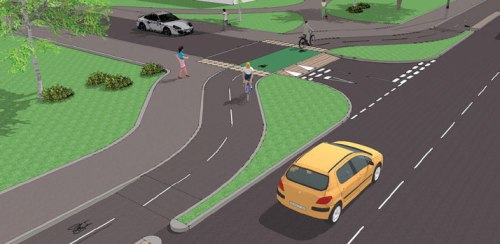
Anyway this is a long and boring way of saying that according to the design, the junction of Dick Lane and Grange Avenue should look like this:
And not like this:

Though I think we now know where the silly wiggle came from. It seems it’s an amateurish and foolish attempt to shrink down the example junction into the space available.
The example junction in the diagram isn’t actually too bad. There’s a few mistakes (the narrow cycleway, the cycleway curve and ramp are too sharp, the visual priority is poor, there’s no need for the tactiles, there’s no continuous footway) but it’s generally the right idea. There’s actually a British example of this with good visual priority (though no footway) and a not-quite-as-good example here. You can watch a Dutch version in action here.
It’s a good design, because it allows turning cars to deal with crossing the cycleway separately, in two distinct steps. It also gives people on bikes time to react to a turning vehicle if necessary, as they’re not riding right alongside the turning car. It also means that cars being driven out of the side road don’t block the cycleway while they wait for a gap in traffic on the main road.
Lost in space
But there’s clearly no space for that here! Well, there is space – tons of it, as you can see from above:

Narrow medieval streets, anyone? (Photo: Google Maps)
A lane could be removed from the gyratory (shock!) or the main road could be moved west to create space for a wider cycleway and proper junction treatment.
But I can hear the excuses already: there’s not enough money in the budget to do that, it would mean moving utilities, we’d have to cut down a tree, it will reduce the almighty motor capacity, and so on.
But if that’s the case, then why did CityConnect specify that type of junction here, where it clearly doesn’t fit within the space given? I suspect that’s the only bi-directional junction they had in their toolbox, so it was simply slapped on here without much thought.
So, let’s see what we can do within the current space.
No more complaining, here’s some suggestions…
Bear in mind, this option is compromised: the cycleway is already far too narrow, and two-way cycleways need to be designed with care to mitigate the additional risks they present at junctions.
A better option would be to make this cycleway one-way, and have the northbound cycleway on the west side of Dick Lane (as suggested by Jitensha Oni on Twitter). There’s certainly enough room between the carriageway and the park wall. I think that would be a better option, as it reduces the number of interactions on the east side.
But whether this happened or not, there are two things that could be done to improve matters:
• Make Grange Avenue (the side road) one-way, therefore becoming ‘no entry’ at this junction, or even removing the junction altogether.
• Give the cycleway and footway visual priority across this junction by using contrasting materials.
I can’t see a reason why Grange Avenue is a two-way through route, as it just connects back to the main road around the corner anyway. I’d suggest simply blocking it off altogether at this junction. Or, if it must remain open for some reason, it could be arranged like this (my suggestion in red):
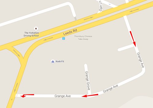
Original map: Google Maps.
If Grange Avenue was made a one-way street then people on foot and bike only have to worry about motor vehicles approaching from one direction. (At the moment, a 270° view is required when cycling southbound!)
More detail, please!
Okay, let’s do our best under the circumstances. It might look like this:

I’ll shout this: THIS IS NOT MY IDEAL DESIGN! THIS IS STILL FLAWED! Please read below…
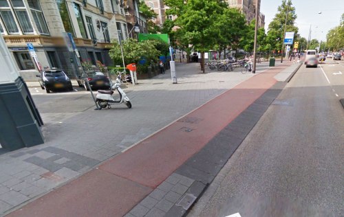
The footway and cycleway should be surfaced in materials which contrast with the carriageway, to give clear visual priority to the footway and cycleway.
The footway will ideally be a light colour, using light paving slabs (reinforced to handle the weight of motor vehicles, of course) and the cycleway should be surfaced in red asphalt (specifically, machine-laid red 55/10 HRA).
Ideally the entire cycleway should be in red asphalt, but unfortunately black has already been used. So as we’re dealing with a remedial fix here, the surfacing must extend along the footway and carriageway beyond the junction in both directions for several metres in order to provide the visual priority required.
The footway and cycleway need to be at footway height across the junction – i.e. with an ‘upstand’ of around 12.5cm.
To achieve this, as the cycleway approaches the junction, it will need to very gently rise up, over several metres so it’s barely perceptible, until it becomes level with the footway for a few metres before and after the junction.
At the junction, therefore, motor vehicles will need to climb a ramp to mount the crossover area, then descend a ramp into the main carriageway on the other side.
A cycle symbol and an arrow should be painted on the cycleway where it crosses the junction. (Assuming the cycleway is still bi-directional, there will need to be one in each direction.)
Finally, a “STOP” line and sign could be placed before the ramp at the end of Grange Avenue, to reinforce the footway and cycleway priority.
The finished thing might look vaguely like this (use a little imagination):
I’ve flipped this so it makes more sense to UK eyes. (Photo: Google Maps)
The design is still not ideal, though the main problem now is that the cycleway is far too narrow to be bi-directional – making it one way, would be preferable. But either way we’ve solved the left-hook problem and made priority very clear.
Unfortunately, unless a lane is removed or the road is shifted, there isn’t enough space for a car exiting Grange Avenue to wait beyond the cycleway and footway, which will mean that it would occasionally be blocked by a car waiting for a break in traffic on Dick Lane.
Note that this actually looks a lot like CityConnect’s other design for where a cycleway crosses a junction, albeit much improved.
Now about my fee…
99 bottles of beer on the wall…
The frustrating thing is, this is just one junction out of hundreds, maybe even thousands, on the CityConnect project. How many more have been dangerously designed, or changed without notice?
I’ve been informed about several dodgy bits by concerned people in Leeds, and I’ve spotted many more on the plans that are either vague (just like this one was, pre-installation) or look like they’ll be very fiddly by bike (think multiple toucans and 90º turns).
It’s exhausting looking through all the information around just this one junction, so I do appreciate the scale of the work involved, and the time and effort that local cycle campaigners must have put in when reviewing the plans.
But, in some locations at least, the finished infrastructure is still far from good enough. Perhaps it’s due to the way the project was funded – a limited amount of money that has to be spent on a big scheme within a short time period. So the money was spread too thinly, and the plans were rushed. I don’t think we build motorways like that.
Or maybe it’s due to the lack of interest the local councils seem to have in the scheme now that the £18m cheque has cleared and the Tour de France has left town.
I’ve been told by several sources that people high up in Leeds City Council insisted that the “Cycle Superhighway” must not – under any circumstances – reduce motor vehicle capacity. That, apparently, is a red line that was not to be crossed.
What sort of attitude is that? It may be 2015 where you are, but it’s still 1970 in certain rooms inside Leeds Town Hall.
Under constraints like that, I can see why at least some of the route is turning out to be disappointing, and I do have some sympathy for the people behind the scheme as they try to achieve big plans with so little time, money and support from above.
Not all of it is bad, some sections do look pretty promising, and I’d genuinely love to see photos and videos of the good bits too. But the problems do need fixing – the junction featured here is a real howler. If there hadn’t been an outcry about this one junction, who knows how many times this awful design might have been repeated throughout the route?
As public money is being spent on this project, it’s only fair to scrutinise it in public too. If the conclusion is that central government’s bizarre funding restrictions doomed the project from the start, or that the council is choking bits of it to death, then this should be acknowledged rather than letting the PR department pretend everything is fine. This isn’t a witch-hunt, I just think the public deserves to know what went wrong, and why.
Still to come, one day: the canal towpath of doom, and a huge junction full of toucan crossings.
 The Alternative Department for Transport is written by, and the personal opinion of,

Pingback: Bradford’s new Cycle Super Deathway | The Alternative Department for Transport
Pingback: Leeds-Bradford CityConnect: an update | The Alternative Department for Transport
Yay 55/10HRA (I would have also accepted AC10)!
I think the maintaining traffic capacity is key here – not written down in briefs, whispered in corridors, members being briefed by senior officers who won’t rock the boat. It is the people on the ground who get shafted.
We have had a project off and on to use subways (really poor ones) for cycling. I came out and said it was bollocks – I might end up sacked at some point, but how liberating!
If only all highways people could be like you! We need honest appraisals, surely it’s part of an engineers’ job to give opinions on matters like this?
From what I’ve been told, your description of the motor-centric pressure behind the scenes is spot on.
We do build Motorways like that! and its an even more expensive mistake thyat goes on giving – classic is the M8 through Glasgow, still falling down in places 40-years on and with pedestrian routes a bolt-on post-build fix – some still to be completed as planned (if ever)
It sounds like the motorway is fine, but the non-car bits have really suffered!
I had thought about making it one way. I think the issue would be that residents approaching from the West would have to go all the way to Thornbury Barracks junction to turn round and come back to enter Grange Avenue.
Yeah, but then the residents of the streets to the east of Grange Avenue have to do that anyway, and yet they continue to live.
Do you know what’s going on at the junction of Bradford Road with Woodhall Lane/Galloway Lane? The current layout on Google Maps doesn’t match the planned works for this junction.
If it’s still possible to u-turn there, then I don’t think the drivers of Grange Avenue are suffering any hardship.
Perhaps the best solution is to close off the other end of Grange Avenue. What concerned me about closing off this junction is that it’s narrow and larger vehicles would have to reverse a long way to get out. But the other end is much wider, so a bin lorry has enough space to turn around.
But then that leaves us with a narrow bi-directional cycleway which has vehicles turning across it in both directions, which is pretty poor. Could the northbound cycleway be moved over the road?
Maybe there’s a point at which we simply have to say, “it just won’t work, there’s not enough room here to do this, we need to think of a bigger, better solution.” I suspect that point has been reached here.
Ok, bit of a complicated one this.
It is being done under the DfT pinch point scheme, so not being funded directly by CityConnect. It’s currently a roundabout and the new layout will also be a roundabout but with a cut through the centre, pretty much as seen on the plans here: http://cyclecityconnect.co.uk/downloads/Sheet%201%20of%201.pdf
I think the reason that google maps is all up the spout, is that during the works they have stopped the right turn if travelling east bound, and the left turn if travelling west bound.
I can’t find any proper plans apart from this one http://democracy.leeds.gov.uk/documents/s109538/thornbury%20barracks%20report%20plan%20v2%20240214.pdf
Whether it’s correct I don’t know. Facility for cyclists on the superhighway is good, across in one signal phase. For those wishing to enter or exit the superhighway from the north or south, less good. I think it’s bi directional cycleways and toucans further east and west of the junction.
It truly is a piece of shit for pedestrians though.But pinch point funding…must get the cars through.
My main reason for asking was to see how much further residents of Grange Avenue would have to go, if their street was made one-way. As the new layout of the roundabout permits u-turns (two-stage, welcome to the club, drivers!) it’s hardly a massive inconvenience.
“It also means that cars being driven out of the side road don’t block the cycleway while they wait for a gap in traffic on the main road.”
Unless there’s more than one car queueing? Or anything longer than a standard car, like a van, lorry, bus, etc.
Sorry for the slight aside, but I’ve wondered about this idea before. The cycleway at this junction: https://goo.gl/maps/iU14b
…is almost constantly blocked by multiple/longer vehicles, despite the (badly worn) box junction.
Yes, it’s not infallible. A second vehicle should wait behind the footway and cycleway until the space at the junction mouth is clear. And longer vehicles obviously have no choice but to block the cycleway, though the vast majority of vehicles entering and exiting a small residential like this will be cars.
“It’s a good design”/”it’s not infallible” ?
“A second vehicle should wait behind the footway and cycleway until the space at the junction mouth is clear.”
Should wait? You think so and it seems obvious to me, but ime the drivers often disagree and no-one’s going to stop them, so I’ve found this arrangement to be pretty useless.
You can introduce caveats now about where it might work best, but small quiet residential street aren’t generally the problem areas.
The give way lines Dan mentions should help, but I would agree with many others that the road layout needs to be a national standard, clear to everyone who owns a driving licence.
Well yes, it’s a good design but not infallible – I don’t think those two are mutually exclusive!
It works really well where I’ve seen it. The NL video I linked to is great, and it’s a much busier junction than the one in question.
What arrangement would you suggest?
Agreed regarding national standards for cycling infra. It’s amazing that it isn’t the number one goal of the big campaigns.
Tim … it’s because there are give way signs ont eh cycle path, so cars/etc have priority.
Here is another junction in Leeds … much more like the one that should have been put in at Dick Lane.
I’ve been collecting links about cycleways crossing side roads and commenting them here (some pending moderation ..)
http://www.magnatom.net/2015/05/bears-way-heaven-or-hell.html
I’ve also posted this link on “As Easy As..”.
Quote: “The Department for Transport, is compiling a set of Case Studies that exemplify high quality, high performing cycle infrastructure in the UK.
The DfT are requesting recommendations of good on-highway cycle solutions that they can publish as Case Studies.
They are particularly interested in on-highway cycle solutions, rather than cycle facilities located away from the highway (except where a highway project derives part of its success from them).
Please send your suggestions as soon as possible – and by Wednesday, 10 June at the latest – using this link: http://goo.gl/forms/Wg8aG6VJxo ”
I’d ask people to reign in their possible (and understandable) cynicism. The only way we as an engineering community will learn what infrastructure needs to go in is if cyclists point out what works for them and what doesn’t, and get this information into official documentation. BTW, I assume this is aimed at engineers, since it came through the CIHT, but its people on bikes who best know the good from the bad, and those two groups don’t always intersect.
City Connect Programme Board Statement on Grange Avenue is published… http://cyclecityconnect.co.uk/downloads/Grange_Avenue_Statement.pdf
Thanks for sending this!
So it’s staying as it is, due to various weak excuses. Very poor show.
But it isn’t, as they say it is, in line with TfL’s Fig 2, is it? Or is there a give way on Grange Avenue out of shot? Thanks, BTW, for all your work on this. I have too little patience remaining to do this kind of dissection these days – I just get angry and start crying in the light of the Chapeltown Road and Cookridge Street fiascos I blogged previously – so having someone is a huge help to put the pressure on to do this right.
I think there is a give way triangle to the left, out of shot, yes.
I’m glad you like the blog! Did you write the Motorway City of the Seventies blog?
Me and Lizzie did, yes. Would like to have done more but I found it emotionally quite draining.
I know the feeling, it is draining to go through all this stuff, make sense of it, then try and present an explanation of the problems in an understandable way.
I did enjoy reading that blog, though!
Looking forward to the Towpath of Doom article!