Thoughts on Chris Boardman’s appointment as Walking & Cycling Commissioner for Greater Manchester

So Greater Manchester now has a commissioner for walking and cycling – Chris Boardman.

This is good news! Boardman, like so many other transport cycling campaigners, comes from a sports cycling background, yet he seems to totally understand transport cycling.

Although I did criticise him for overstating the effects of liability insurance legislation a few years back, nearly everything Boardman says is absolutely spot on.

I was particularly impressed when watching this video, in which, after Mayor of Greater Manchester Andy Burnham speaks of the job as being “for cyclists”, Boardman immediately clarifies his position:

“My job as I see it is not actually for ‘cyclists’ – it’s for normal people in normal clothes doing normal things, getting from A to B and using bikes and walking to do it, and we’ll only do that if it looks easy, it’s appealing and it’s right in front of me.

“So our job – my job – is to make sure that that space is there, that safe space, a genuinely viable, attractive option for people to move around by bike.”

Gets a thumbs up from me!

And although Mayor Burnham sometimes seems to be a bit confused about the difference between sport and transport, Boardman appears to have confidence in the Mayor that his intentions are right.

And the intentions really do need to be right, because the city is failing to achieve its goals so far.

Good intentions from 2013 failed to materialise

In 2013, Transport for Greater Manchester revealed their plan for cycling, which aims to increase transport share from 2% to 10% of journeys within 12 years (i.e. by 2025).

Their targets at the time included doubling the number of people cycling by 2015 (did that happen, anyone?) and to complete seven cycleways running into the city centre by 2016.

Now here we are, four years after the plan was released. One third of the allotted time has passed, so surely they are well on their way to achieving these goals? Are there seven safe cycleways full of smiling citizens?

It seems not.

As far as I know, only one of those cycleways was completed, and mostly to a very poor standard. (In short, some of the bus stop bypasses are okay, but nearly all the rest needs a real highway engineer to redesign it.)

So now Greater Manchester has just eight years to create radical change on a massive scale.

Meeting these targets – which they set themselves, remember – will mean an intense programme of road rebuilding . It will mean removing car parking spaces and blocking off side-roads. It mean making changes that some people will vociferously disagree with. It will mean having the political courage to push those changes through for the greater good.

Hope and cynicism

I hope that Boardman has the political power and authority to overrule the pro-motor dinosaurs who are no doubt entrenched within Greater Manchester’s roads authorities. (I can’t imagine it’s the only part of the UK without such people in local government?!)

I hope that Boardman has the honesty and integrity to tell us if his work is being frustrated by said dinosaurs. And if those dinosaurs get their way, I hope he has the courage to say publicly, “this road design isn’t good, I do not approve of it.”

There will be challenges ahead. The usual anti-cycling fear-mongers will now be sharpening their pens, pitting cycling against walking and against people with disabilities, they’ll be preparing tales of lost business and “traffic chaos” (just as shopkeepers in the Netherlands did in the 1970s before they learned that cycling was their friend, not their foe).

I admit, I do remain cynical. I worry that the role of commissioner could be intended to placate progressive transport campaigners, someone to distract activists and soak up dissent. I also worry that the authorities in Greater Manchester don’t have the desire or knowledge to make good on their promises, as we’ve already seen.

But I have lots of confidence in Chris Boardman. He really does seem to get transport cycling, perhaps more than any other prominent figure in the industry. He’s seen what real cycling infrastructure looks like, and he knows how it can transform a city for the better.

(And I’m sure he has no desire to be sidelined into acting as a mere PR mouthpiece wheeled out occasionally to greenwash some half-baked road design or promote some soft-measures fluff.)

So I hope my cynicism is proven wrong. I hope that in a few years I can look back on this post and say, “hey you miserable git, you were wrong – Chris Boardman and TfGM are transforming the area into an efficient, clean, modern metropolis!”

Real change, real people

I’ve got good reason to hope that my cynicism is proven wrong – I’ve got family in Manchester, one of whom is a young boy of 2.

In 2025, he’ll be 10.

Will he have anything like the freedom that children in Dutch cities have? Will he cycle to school with his friends, without his parents worrying about him, as is the norm here in the Netherlands? Will they cycle together as a family on a weekend, as I see so many families doing here in Groningen?

Or will he be like my 8 year old niece in Leeds, who walks only from the front door to the car, to be driven everywhere thanks to a city council which has spent 50 years making sure its residents have no other decent option?

So, as you can see, I really want Chris Boardman to succeed – because that means that Greater Manchester succeeds, which means a better environment for everyone who lives there.


8 Comments

Filed under Uncategorized

Crap Groningen Cycling Infrastructure #2 – Noorderhaven

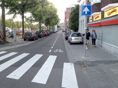
Here’s another piece of recently installed crap. It’s the north side of Noorderhaven, which forms part of Groningen’s bizarre inner ring road.

As you can see, there’s plenty of space here – two rows of parked cars! – but no safe space for cycling.

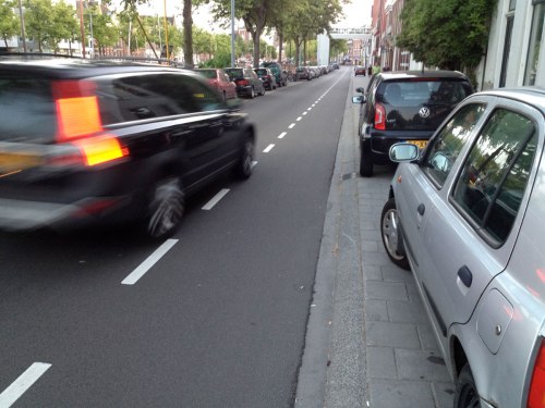
Instead, people cycling are expected to ride between parked and moving motor vehicles, in an advisory painted cycle lane which offers no protection whatsoever.

In a city which claims a 60% modal share for cycling, doesn’t it seem strange that the transport department prioritises the storage of static metal boxes over the safety and convenience of the people using the city’s most popular transport mode?

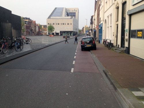
Noorderhaven Groningen, two lanes of car parking, no protected space for cycling

So there’s space for two lanes of parked cars, but only a narrow painted advisory strip for cycling? This is UK-quality infrastructure in what claims to be one of the world’s top cycling cities. Also, the usable width of the footway is very narrow due to the cars parked on it.

Noorderhaven Groningen, car zooms in cycle lane

Would you feel happy for your children or your grandparents to cycle here, between the parked cars and the moving traffic?

Noorderhaven Groningen, elderly man cycles in painted lane

Nobody should have to cycle this close to large vans, protected only by a white line – especially where there is ample space for a cycleway.

Could there be a good reason for such poor and dangerous infrastructure where there is clearly space for much better?

I just don’t understand why Groningen seems to be building for the 1970s rather than building for the future – or even for the present day.


For those of you interested in such things, this road was reconfigured in August 2015. Previously there were two lanes for motor traffic and nothing at all for cycling. The footways have been widened, but they’re full of parked cars, so there isn’t actually any more space to walk in. The council has essentially created an extra row of parking spaces – strange decision for a “fietsstad”, no?


1 Comment

Filed under Uncategorized

Groningen does not have a 60% modal share for cycling

I’m not sure why, but it annoys me that a 60%+ modal share for Groningen keeps being quoted. Perhaps it’s because I prefer facts to hype?

This figure seems to have been arrived at by conveniently removing walking from the statistics, which means that every other mode’s number can be increased by about 30%.

If you read that whole Twitter thread, you’ll note that the local government mouthpiece (whose mission is to praise everything that the council does around cycling, whether it be good, bad, irrelevant or an insult to our intelligence) doesn’t even know the modal share for walking – although they’re happy to make a guess at “1 or 2 percent”, which is laughably low for a city like Groningen, which has a city centre filled with residences, and lots of local shopping areas in the suburbs.

I couldn’t find any modal share stats for walking in Groningen, but a recent Dutch government report gives a 25% utility (i.e. not recreation) walking share for Utrecht, and a 30% share for Rotterdam, Den Haag and Amsterdam (PDF here, see page 20). Why would Groningen’s walking share (and it’s a very walkable city) be so much lower than other Dutch cities? At “1 or 2 percent” the walking share in Groningen would be lower than Detroit.

This trick of erasing walking is the same one that the Fietsersbond used a few years ago to inflate the cycling figures for Amsterdam.

The other, more common sleight of hand which city cheerleaders use in order to quote an impressive-sounding number is to present the commuting share as the overall share. (The modal share for cycling at rush hour is usually much higher – more on this here and here.) Interestingly enough, the same Dutch government report that I linked to above gives Groningen a 60% commuting share for cycling – which is believable, and possibly also a source of misinterpreted figures, but is not the same thing as the overall share.

Anyway, most statistics I’ve seen which do include walking as part of the transport mix put cycling in Groningen at nearer 40% (see the spreadsheet linked from here and this PDF, for example). This is still a hefty mode share, and a number which most cities around the world can currently only dream of achieving.

Measuring transport is very complicated, of course – do we measure by distance, or by time, or by trips? What if a journey involves multiple modes? How do we collect and measure this data? As you can imagine, it’s pretty involved, and it can be tricky to compare stats between cities which may be using different methods. But choosing to leave out walking – or to only give the commuting figures – doesn’t give an honest representation of the truth, and only makes the figures harder to compare between cities.

I’m not trying to do Groningen down here (I moved here, after all!) and it does indeed have a large amount of cycling. But the local authorities seem to have been resting on their laurels for many years now, with cycling numbers clearly boosted by the huge student population, and it feels like PR has been chosen over investment in infrastructure. While there is some good new infra, there are some downright dangerous designs too, and it seems strange that even a city which claims such an amazingly high cycling share often finds it difficult to prioritise this key transport mode, or even to maintain its existing infrastructure.


That last link, by the way, points to Mark Wagenbuur’s 2016 post about Groningen, which I’ve just re-read, and have realised that it’s basically a perfect summary of everything I wanted to write about Groningen (although I’m rather fond of the simultaneous green, but I agree with Mark that the signal phasing isn’t always done well here).

4 Comments

Filed under Uncategorized

Good Groningen Cycling Infrastructure #1 – Sontweg

Well it wouldn’t really be fair to tell you about the bad bits of Groningen cycling infra without mentioning some of the good bits, would it?

And there really are plenty of good bits. I love living here – in comparison to Berlin and London, Groningen is a dream to cycle in.

As a fairly new arrival here, I find that using the history feature on Google’s mapping software provides an interesting glimpse into the city’s recent past. It’s possible to see how things change over time – some for the better, and some for the worse.

Mostly, however, it’s for the better – the general trajectory in the Netherlands seems to be upwards.

And that’s certainly the case on Sontweg, a fairly large road that heads east out of the city (or west into the city), running past one of those trading parks full of big-box stores like Ikea.

Over the past decade, Sontweg has been through some major changes. Once it was a fairly minor route around the edge of a peninsula, but in the past decade two new bridges have been built*, joining Sontweg up with roads to the north and the east.

Now, we could talk about the wisdom (or lack thereof) of creating new routes for motoring, but one thing I can’t complain about is the cycling infrastructure that’s been built as part of these road upgrades.

Here’s Sontweg just three years ago, in May 2014:

Sontweg in Groningen in 2014. Only unprotected cycle lanes, despite acres of space available.

Of course, the unprotected cycle lane is blocked. (Source: Google Maps)

Pretty gruesome, eh? Despite all that space, nothing but cruddy old unprotected cycle lanes, despite this being a route for industrial traffic and also the main route into town for the fire brigade’s emergency vehicles.

Anyway, let’s look at the same scene in July 2016:

Sontweg in Groningen in 2016, featuring proper protected cycleways.

Ah, look at those beautiful ribbons of red asphalt! (Source: Google Maps)

So as you can see, there’s been quite an upgrade.

The main road widening has added a bus lane on each side, and there’s also an intermittent turning lane / crossing island in the middle.

But for me the most important addition is the cycleways, one on each side, surfaced with smooth red asphalt, and set back from the road.

Wide cycleway of red asphalt with forgiving kerbs and separation from road

This is how I roll… to Ikea, anyway.

Cycleway on Sontweg in Groningen. Made of red asphalt. Cycleway passes a bus stop, which is on a raised platform by the road.

And this is how I roll back again afterwards. It’s an exciting life.

It’s a fine piece of cycling infrastructure. Top marks to whoever was behind this scheme.

My only criticisms (I can’t even go one post, can I?) are that some of the junction mouths on the south-western side should be tightened up, and that the cycleway could be wider. It’s comfortable, but when you’re riding side-by-side with someone, and a third person wants to overtake, it can be a little tight. And there’s plenty of space for a wider cycleway too – it’s strange that it’s not wider, considering Groningen’s claimed modal share you’d expect them to be building for the future.

First world problems, eh! Anyway, I think that a cycling campaigner’s default position should be to always want more space. After years of being squeezed to the sides, cycling needs people who demand more space.

So, there we are – good progress, from bad infrastructure to excellent.


* One of those two new bridges is the one which helped Groningen to lose out on the Cycle City award in 2011, though of course in the UK it would be winning prizes left right and centre. See David Hembrow’s blog posts about it here and here.

For more photos of good cycling infrastructure, I can recommend the Cycling Embassy of Great Britain’s Good Cycling Facility of the Week.

1 Comment

Filed under Uncategorized

Crap Groningen Cycling Infrastructure #1 – Damsterplein

Wow, it’s been quite a while since my last post, hasn’t it? Sorry about that. I’ve missed you too.

In my defence, I’ve been busy adjusting to life in Groningen in the Netherlands – yes, I’ve moved to one of those places which people like to go on and on about because it’s great for cycling.

And Groningen really is great for cycling – mostly.

While the city and surrounding areas are generally very good or even excellent for cycling, there are many baffling gaps, neglected corners, and dangerous designs.

So after spending years praising many good bits of infrastructure in this country, I think I’ve earned the right to complain about some of the bad bits, the exceptions to the cycling wonderland that is the Netherlands.

So let’s start with Damsterplein, shall we?

Damsterplein: I think that’s Dutch for “disappointment”

I first experienced Damsterplein completely by accident, riding around the city when we first arrived, in the spirit of happy exploration. I was stunned to find such a large, busy road without any good cycling infrastructure – only intermittent, legal-to-drive-in “advisory” cycle lanes, which disappear at bus stops so that buses can pull in.

Since that first visit I’ve avoided using the road as much as possible. I cycled through there recently, to take photos for this blog post, now in the spirit of brave investigation. And yet although I’ve only ridden here maybe half a dozen times, I’ve had an unpleasant experience every single time, usually caused by having to pull out into a stream of moving motor traffic in order to overtake a bus legitimately waiting at a bus stop, or a car parked in the cycle lane.

Every. Single. Time. Now you can see why I avoid riding there.

So here’s a few pictures, some which I took myself, and some from Google Streetview to prove that I’m not cherry-picking rare situations. Avid cycling blog readers may recognise Damsterplein, as David Hembrow has mentioned it in a couple of blog posts.

Damsterdiep cycle lane parking 1

Luckily for this guy, the Streetview car was hanging back (Source: Google Maps)

Damsterdiep cycle lane parking 2

Does this look like an “8 to 80, all-abilities” cycling environment to you? (Source: Google Maps)

Damsterdiep cycle lane parking 3

It’ll be fine, he’s just nipping in to the shop for a few minutes. Don’t worry about the bus that’s about to overtake you. (Source: Google Maps)

Damsterdiep cycle lane parking 4

Motor vehicles parked three-wide, one lane of moving motor vehicles, and no actual space for cycling here on the southern side of Damsterplein.

Damsterdiep cycle lane parking 5

After I took this photo, the driver of the car behind me decided to overtake as I was passing this parked car. I will not cycle here again.

And if you thought the cycling “infrastructure” here looked crap, then the footways aren’t much better. All the cars in the photos above which appear to be parked on the footway are in fact parked legally. Here’s an unusually car-free section:

Crap footway parking on Damsterplein in Groningen

The dark line marks the official edge of the parking space, leaving just a metre or so for walking – and that’s assuming that the vehicle is parked perfectly within the space. (Source: Google Maps)

This arrangement is pretty crap for walking. It’s not much fun finding a van mounting the kerb toward you, and as a recent case in the UK tragically showed, having motor vehicles mounting the footway can have lethal consequences. Could a young child be expected to know that the black line denotes a parking space into which a motor vehicle may be driven?

This footway parking design also means that cars and vans must be driven across the cycle lane in order to access the parking spaces, which creates delay and danger for people cycling – and this also means that the cycle lane is now in the door zone.

I also worry that this kind of design for parking essentially legitimises use of the footway for other things (rather like the “shared footway” designs in the UK legitimise pavement cycling). It conditions people into parking on the footway, not just here but in general. It says “don’t worry if there’s no parking space, just stick the van on the footway, it’ll be reet for a bit.”

And all this motor-centric (and anti-cycling and anti-walking) design exists despite there being acres of space here in which to get things right. See how much room for manoeuvre the driver of this car has within the single humongous traffic lane:

Extremely wide carriageway for motor vehicles on Damsterdiep in Groningen

Narrow, medieval streets?

A sea of asphalt, about three cars wide, and yet there’s no space for proper cycling infrastructure? I’m calling bullshit on that one.

(Also, how about those tyre marks? Do they suggest safe and careful driving? What you can’t see on this cropped photo are the motor vehicle tyre marks along the cycle lane…)

Cycling backwards through time

Anyway, I was going to end my post there – these “Crap of the Week” posts are meant to be brief – but while looking at old Streetview and aerial photos, I learned a little bit of recent history about the place, and my distaste for the current layout grew deeper: it’s brand new.

Well, almost – the current layout was built between 2008 and 2010 as far as I can tell. Here’s how the street looked 10 years ago:

Satellite image of Damsterdiep in Groningen, showing cycleway along southern side and painted lane along northern side

Here’s the western end (closest to the city centre) in 2007. None of the current square exists, but there is a cycleway on one side of the road. (Source: Google Earth)

Damsterplein Groningen east 2007

And here’s the eastern end. Note that a single-lane road becomes four lanes at the junction. (Source: Google Earth)

So heading west into the city, it’s always been pretty crap – the cycleway suddenly ends at the junction with Oostersingel, and people were (and still are) expected to cycle around a jumble of parked cars and stopped buses. That hasn’t changed.

But heading east, out of the city, the cycling experience has become so much poorer. In 2007, after crossing the bridge over the canal, a protected cycleway begun almost straight away and took you safely all the way to the huge junction to the east. That’s now gone.

Overall, however, the square that is now Damsterplein looked like a pretty dismal place, essentially a large car park. So the city decided to spruce things up by creating a new public square (a fine idea!) underneath which would be a massive multi-storey subterranean car park.

(Now this car park is interesting in itself. It’s often said that for a city to be cycling-friendly, it must be hostile to driving. And yet Damsterplein isn’t the only brand-new underground car park in Groningen. The city must be spending millions of Euros on these things, which doesn’t seem like the actions of a body that wishes to discourage people from driving into the city.)

So, the whole area – the entire massive space between the buildings – was being redeveloped. Every centimetre would be dug up and replaced. This was a blank canvas, on which millions of Euros would be spent.

Groningen Damsterplein in 2008, a huge hole in the city, wasteland ready for development

Damsterplein in 2008. All of this ground was about to be torn up and replaced. (Source: Google Maps)

Surely with such a large-scale project, the citizens of Groningen could expect some top-notch cycling infrastructure for their money?

For at least two years all vehicle access had been severed – enough time for people to adjust their travel patterns and become accustomed to the idea that Damsterplein wasn’t a through-route for motors. Surely a golden opportunity to introduce a pleasant, motor-free square on the edge of the city centre.

Here’s the same view today:

Damsterplein in 2015. Four lanes of motor traffic exiting at the main east-side junction.

Damsterplein today. Seven lanes of motor traffic – beautiful. (Source: Google Maps)

Now the seven lanes of motor traffic you see here aren’t as bad as they look, as at this end of Damsterplein there are proper separated cycleways – but the size of this junction suggests that the amount of motor traffic circulating around Damsterplein itself is too large for cycling to be mixed in with it.

Instead of the peaceful motor-free or very-low-traffic square that was surely possible, Damsterplein is instead surrounded by rumbling engines on all sides.

I’m staggered that with all the changes that have gone on here (and since completion there have been retrofitted tweaks for buses and for car park traffic) the designers decided not only to rebuild the old unprotected cycle lane on the city-bound side of Damsterplein, but also to copy that dangerous design across to the outbound side too.

This is a city which claims a 60% modal share for cycling (which isn’t actually true, but we’ll come to that another time) and yet even here, cycling infrastructure is chipped away at and downgraded in favour of motor vehicles.

I could forgive crap infrastructure a little bit when it’s old and in need of replacement. After all, Rome wasn’t built in a day. But when something is just a few years old – designed and built with wilful ignorance of all that we know about good cycling infrastructure, and the dangers of mixing heavy motor traffic with cycling – it’s completely unforgivable.

6 Comments

Filed under Uncategorized

Another visit to Leeds’ unfinished “Cycle Superhighway” with no end in sight

Note: For all those Evening Post readers who email me to complain about cycling in general – I’m not against cycling, or cycling infrastructure. The reason you spend so long sat in traffic is because Leeds has given people no other option but the car. Leeds needs cycling infrastructure. So the concept behind this scheme is sound – but the execution is very poor, and that’s what I’m criticising here.

Well here we are again, back in Leeds. And it’s the same old story – delayed works, lack of communication, bad design and broken promises. The eastern cycleway – from the city centre, along the A64 York Road, out to the A6120 Ring Road – still isn’t finished, despite several completion dates passing without comment.

It’s difficult to know where to begin when writing about the City Connect project, as there are so many bad points to cover. So maybe I’ll start with one or two good things that I saw, to begin on a positive note.

The good bits

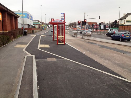
Well firstly, this bus stop bypass isn’t too bad. The cycleway could be wider, especially considering the massive width of the road, but the kerbs are forgiving, and there’s a verge separating it from the road. There are no sharp turns at the bus stop, but I’m not sure about the pedestrian crossing angles, though the difference in surface colour should help.

An overhead view of a cycleway at a bus stop bypass in Leeds

Some sections of kerb are extremely forgiving – maybe even too much, as when the cycleway and footway are both surfaced in the same black asphalt, the difference isn’t clear enough. Really, the cycleway should be a different colour asphalt.

But this is much better than the pseudo-forgiving kerbs used on some other cycleways, which are too high and/or too steep.

A close-up photo of the join of a footway and cycleway in Leeds. The kerb between the two is short, with an angled side. The cycleway is lower than the footway.

And that’s about it. I’m afraid that’s pretty much the extent of the good stuff I saw. (And not all the kerbing is as good as that bit, either.)

Changes, delays and silence

This section of the project was meant to have been finished months ago – last year even, perhaps – I’ve lost track of the number of times that the deadline for opening has been missed. The latest update from City Connect said that the work was to be completed by the end of October – so these photos, taken in early November, should be of the finished article.

Earlier this year City Connect tried to fob us off with a sleight of hand, splitting the route into two parts so that they could declare the project complete in June, despite only the western section – now branded CS1 – being finished. This eastern portion, labelled CS2, remains incomplete.

When I was there at the start of November, it was clear that there are still lots of physical engineering works which haven’t been done, but the solution seems to have been to quickly cover up the gaps with paint so that the City Connect PR machine can pretend it’s finished for now.

Quite unlike the promises of excellent infrastructure made at the start of the project, much of the “Cycle Superhighway” resembles the usual failed excuses for cycle infrastructure which any British cycle campaigner is familiar with: shared use footways, narrow painted lanes on busy roads, fiddly and inconvenient junctions, long waits at multiple toucan crossings, and so on.

It represents business as usual, not the great leap forward it was sold as.

So easy, it’s child’s play

Along the route there are lots of newly-installed banners proclaiming City Connect’s cycle route to be “as easy as riding a bike”, which also feature the logo of something called Child Friendly Leeds. This is a council initiative which aims “to make Leeds a child friendly city” and claims to believe that a “successful city has children and young people at its heart”.

Banner attached to a lamp post. Text on banner reads: CityConnect. Seacroft - Leeds - Bradford. Your journey, as easy as riding a bike. We are child friendly Leeds.

Well, either Child Friendly Leeds is just another attempt by Leeds City Council to whitewash over their business-as-usual policies, or there will be some very angry people who are annoyed that their logo is plastered over infrastructure which is anything but child-friendly.

Give way on the cycleway, AKA priority for motoring

One of the first things that caught my attention was that several give way markings have been added on the cycleway, despite promises from City Connect that the cycleway would have priority at side roads.

This is poor design: people using the cycleway should usually have the same priority as those using the road, otherwise it just results in slower journeys.

A bus turns across a cycleway in Leeds, with priority

06-leeds-cycle-superhighway-gives-way-at-side-road-exhibit-d

07-leeds-cycle-superhighway-gives-way-at-side-road-exhibit-e

03-leeds-cycle-superhighway-gives-way-at-side-road-exhibit-a

04-leeds-cycle-superhighway-gives-way-at-side-road-exhibit-b

None of this bears any resemblance to the plans that were consulted on, the junction diagrams provided, the agreements with cycling groups, and the reassurances (PDF) offered after the Grange Avenue fiasco that such a junction design would be a rarity.

You’ll notice that on the final photo above, people cycling must give way to traffic from both directions. (In the first four, there is, at least, priority over vehicles exiting the side road.)

But while these give way markings are new, the rot had already set in many months, or even years, ago. The way these junctions were designed, and subsequently installed, it was inevitable that the cycleway would yield to the carriageway. Such junctions with priority squeezed alongside a busy 40mph arterial road aren’t ever going to work safely – hence why painted cycle lanes can also be dangerous, they can lead to the infamous “left hook” collision.

The junctions above should never have been designed like that in the first place. If a cycleway is to cross a side road like this, the cycleway should be set further back from the road, with a raised “continuous footway/cycleway” junction to slow turning vehicles further – which City Connect knew about, as it was included in their junction type diagrams. (Though would this work along a 40mph dual carriageway anyway, or are signals required?)

So while I don’t agree at all with the decision, I can see why someone eventually opted to paint in give way markings at these junctions – not that that makes them safe, but that it ticks a box somewhere, so that the blame for any collision can be placed on the person cycling.

Give way anyway

At some points, there are even give way markings for… no reason at all! The photo below shows the cycleway and footway merging to become shared space at a crossing, but not all crossings are done like this. Sometimes the shared footway starts with a give way marking, sometimes just wheel-grabbing tactile paving slabs.
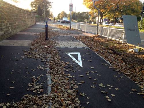
11 Leeds cycle superhighway - give way at crossing.jpg

Vague crossovers

But like so much of the City Connect project, there’s absolutely no consistency at all. Many of the crossovers (entrances to car parks, petrol stations, etc.), often just metres away from the junctions pictured above, do give priority to the cycleway, although it’s done vaguely with just green paint (no white lines) which does little for visual priority.

08-leeds-cycle-superhighway-york-road-car-park-entrance

09-leeds-cycle-superhighway-york-road-petrol-station-entrance

22-leeds-cycle-superhighway-crossover

If it’s safe at these junctions, then why is it dangerous at the others? And if it’s dangerous at the others, why is it safe here? I know that crossovers and side-roads are technically different, but I doubt many drivers will approach them differently here.

Junctions with cycleway priority

To be fair, the cycleway does have priority at some junctions, but this has often been done incompetently, with unneccesarily vague design…
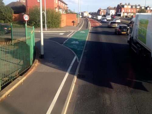
30-leeds-cycle-superhighway-vague-junction-priority

While a flush kerb might have no legal meaning with regards to junction priority, people can still clearly see it, so it’s important for visual priority. Hence, the kerbs which run along either side of the cycleway are good (as they reinforce priority), but the kerbs which cut across the cycleway are bad (because they negate that intended priority). The coloured surface should extend several metres along the cycleway before and after the junction.

…or with sudden, sharp turns.
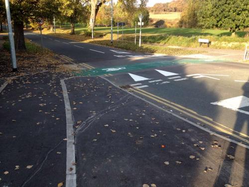
A cycleway in Leeds crosses a side road with priority

Note how there’s no continuous footway here, and the road surface doesn’t change to a different material. The green surfacing doesn’t extend much beyond the junction itself either, and there’s no line marking the edge of the cycleway, which would give good visual priority.

A side road with cycleway priority on Leeds Cycle Superhighway

Here, any cars turning off using this sliproad (designed for speed) will be right alongside (or just behind) anyone riding on the cycleway, just before they make a sharp right-hand turn across their path. At least the priority is clear, due to the give way markings being right up against the cycleway.

An unfinished side road crossing on Leeds Cycle Superhighway

This side road junction is unfinished. But note the tight 90º turns required (we’ve already done two to reach this point). Also note that the kerb cuts across the cycleway, and that the footway is interrupted by the carriageway too.

Furthermore, when the roadworks were done, the kerb line (which cuts across the cycleway for no real reason) wasn’t laid quite flush – there’s a slight drop as the cycleway begins to cross the road, and a slight bump up at the other side.

You can see here where the leaves have gathered against the upstand on the far side of the junction, which anyone cycling along the route must mount as they ride along:

34-leeds-cycle-superhighway-upstand-on-cycleway-with-leaves

In some places, City Connect have covered this up by slopping lots of green paint on there, but it can still be felt, and in some places it causes puddles to form, which will be fun in the winter.

14-leeds-cycle-superhighway-paint-slopped-on-bad-join-at-junction

15-leeds-cycle-superhighway-water-pooling-along-kerb-lip

A sense of abandonment

And at some junctions, there’s nothing at all for cycling. A mixed-use footway simply ends at the junction, as if City Connect simply never existed.

10-leeds-cycle-superhighway-goes-missing

12-leeds-cycle-superhighway-disappears-at-a-very-minor-junction

29-leeds-cycle-superhighway-shared-use-footway-driveway-without-priority

A shared footway (i.e. cycling permitted) crosses a side road on Leeds Cycle Superhighway

This is super, apparently.

Right, said Fred…

Quite often, it feels like the contractors were told just to finish the job as quickly and cheaply as possible, without worrying whether it actually works or not.

In some places, the cycleway vanishes entirely, with stretches of shared-use footway common:

A footway in Leeds where cycling is permitted. About 25% of the width is taken up by telecoms cabinets.

You share with people walking, and with a mobile phone mast and equipment cabinets.

Here, the “Cycle Superhighway” manifests as the amazing piece of infrastructure we’re all familiar with – a white line in the middle of a footway.

Leeds City Council have painted a white line on a footway, and called it a Cycle Superhighway

In this form, it crosses the entrance to a petrol station, before giving up altogether just before the exit. Beyond this point, the cycleway doesn’t even exist as a white line, it simply disappears. Sorry, I mean it Cycle Super-disappears.

Leeds Cycle Superhighway, in the form of a white line on a footway, crosses the entrance to a petrol station before disappearing altogether

In other places, the rush job means that the cycleway becomes an unmarked shared-use footway, which then becomes… a painted lane on the road. Ah, such amazing infrastructure, well worth waiting years for, truly Super!

18-leeds-cycle-superhighway-becomes-a-painted-lane-on-a-fast-busy-road

Even this hasn’t been done well, requiring a double-turn onto a fast, busy road, with nothing but white paint and crossed fingers for protection (the lighter section of kerb-stone is the extent of the dropped area). This whole stretch is utterly unsuitable for anything wider than a bicycle, such as a hand-bike or cargo bike.

Remember, according to Leeds City Council, this is “child friendly” infrastructure – so I’ve taken the opportunity to add the appropriate logo to the next photo.

19-leeds-cycle-superhighway-is-a-narrow-painted-cycle-lane-on-a-busy-road-with-cfl-logo

There’s a motorway-style crash barrier here to protect the traffic lights (presumably), but anyone cycling here will be on the wrong side of it. This probably tells you all you need to know about how much Leeds City Council cares about cycling.

Thrown to the Loiners

This design – rejoining the carriageway at a busy junction – occurs more than once, including on both sides of the major junction with Harehills Road.

On the westbound side, someone has at least had a go at designing a decent transition from cycleway to cycle lane, though such a design has no place at any busy urban crossroads. It’s completely inappropriate to send people cycling into mixed traffic here, a point where they need protection the most.
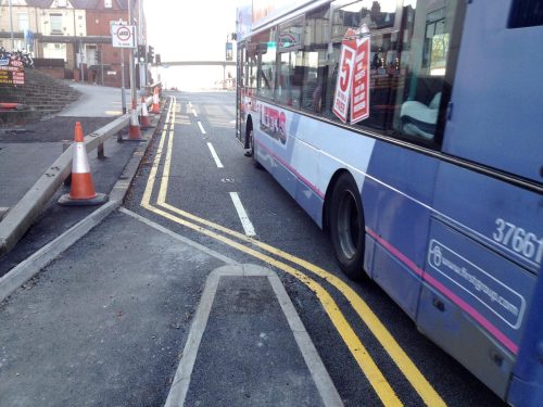
Leeds Cycle Superhighway suddenly turns into a bike lane at Harehills Road junction

Again, there’s plenty of space here. Why are people cycling sent on the wrong side of a crash barrier, to share time and space with heavy motor traffic at a busy junction? Isn’t this exactly the sort of problem that City Connect was meant to solve? Instead they’ve shrugged their shoulders whenever any difficult decision had to be taken.

Heading eastbound, the situation is even worse – although, of course, as the damn thing still isn’t finished, who knows how it will end up? (If City Connect know, they’re not telling anyone.)

Anyway, this is what I suspect is intended: After avoiding people walking or waiting at this narrow shared-use space at a bus stop…

25-leeds-cycle-superhighway-junction-with-harehills-lane-1-bus-stop

…your handbike-using grandma or trike-riding nephew is then expected to “rejoin the carriageway” here, by use of this dropped kerb…

26-leeds-cycle-superhighway-junction-with-harehills-lane-2-dropped-kerb-cycle-lane

Space is clearly at a premium here. Narrow medieval streets and all that.

…and arrive at this mutant ASL, which certainly won’t be full of stopped vans.

27-leeds-cycle-superhighway-junction-with-harehills-lane-3-bizarre-asl

People cycling along the “Superhighway” will be travelling straight on here, remember – i.e. they’re going the same way as the red car – so they’ll need to watch out for drivers turning left at the speedy 1960s-style slip-road junction.

Again, this is exactly the kind of interaction that City Connect was meant to put an end to. What’s the point in City Connect’s existence if they’re not going to fix junctions like this?

Should they survive, sanctuary beckons as the protected cycleway begins again on the far side of the junction (though note the kerb, cutting across the entrance to the cycleway at an angle, which is there for no reason other than to pose a hazard in wet weather).

28-leeds-cycle-superhighway-junction-with-harehills-lane-4-junction-end

In conclusion: it keeps getting worse!

We were promised a first-class cycleway, but we’ve been misled and ignored constantly. Now we have infrastructure which is a real curate’s egg: whilst some bits are okay, much of it is rotten.

I do feel a little sympathy for the people designing this monstrosity, as it’s been said that Leeds City Council forbade even one centimetre of road space to be taken for cycling infrastructure. If that’s true – and I’ve heard it from many sources – then the project was doomed from the start.

But whatever the reason, the designs used by City Connect have been proven to be unattractive, inconvenient and even deadly many times before, yet we’re expected to be grateful for anything at all. Their interest in this project has clearly already dwindled, and they’re on to the next pot of funding already. There’s no consistency, no accountability, and no reliability.

Despite their claims to be an infrastructure project, City Connect now spend most of their time tweeting about cycle training and lights, and very little effort is spent on discussing infrastructure. This seems to be the norm for lots of UK cycling projects – the hard stuff is too hard and too quantifiable, so instead they fall back on “encouragement and promotion”, despite it being proven to be useless – but then, that’s all that’s expected of publicly-funded cycling advocacy in the UK anyway.

Anyway, thanks for reading. I’ll leave you with this, one of the worst bus stop designs I’ve seen in a while, and that’s really saying something. This goes to show that even when presented with a large blank canvas, City Connect can be relied upon to mess things up.

A bus stop bypass on Leeds City Connect Cycle Superhighway. The cycleway curve is far too sharp, and people walking must cross it twice, despite there being lots of space to get it right.

16 Comments

Filed under Uncategorized

Cycleway removed, people are angry

Most people don’t like cycling amongst motor vehicles. It’s a simple concept which many somehow fail to understand.

A popular cycleway has been removed, so now people cycling are expected to use the carriageway. The people who cycle there are upset.

But the local cycle campaign think it’s great that everyone, from children to the elderly, must now cycle amongst cars, vans and buses.

Sounds familiar – could be Britain, right? Well, it’s actually happening in Hamburg.

You can watch a short video about it, from German TV, and below you’ll find a transcript which I’ve translated into English, with help from Katja Leyendecker at the tricky bits.


VOICE-OVER:

Cycling along the Alster [a lake] in Hamburg.

For some, a stress-free route to work. For others, simply relaxation. This, in the middle of the city.

Every day 4,300 people cycle along this stretch. But the joy of cycling here is now over for many. A long section of the old cycleway has simply been removed. Completely without reason, many feel.


MAN IN BLUE JACKET:

It was a wonderful cycleway along the Alster, where one could be really relaxed while cycling.


WOMAN WITH BEIGE HAT:

It’s a real shame, because it was separated, not squeezed together with people walking, it was really well protected and worked so well.


MAN WITH SILVER CYCLE HELMET:

It was an absolutely wonderful, great cycleway. And it is no more.


WOMAN WITH BLUE SCARF:

Cycling along here you could look out at the lake… and now we have to look at cars. What a pity.


VOICE-OVER:

Here, the Hamburg traffic department have planned something different. They want the road next to the existing cycleway to become a so-called “cycle-street” on which people cycling share with motor vehicles.

But it’s not entirely finished – and the cycleway has already been ripped up anyway.


MAN IN BLACK HOOD:

Completely stupid. It’s no fun riding on the road every day.

A view of riding along the cycle-street, between parked cars and oncoming motor traffic

A view of riding along the cycle-street, between parked cars and oncoming motor traffic.


MAN IN BLACK CYCLE HELMET:

It’s unacceptable, because cyclists now have to go elsewhere. And nobody wants to cycle on the road. I already saw a cyclist lying under a car.


WOMAN WITH FURRY HOOD:

I cycle that route a lot, and yesterday I was verbally abused, because I was cycling on the road.


WOMAN WITH BLACK HAT:

It’s impossible, you have to overtake parked cars, kids are expected to cycle here, on their way to/from school, people open car doors quickly, it’s impossible.

A so-called 'cycle street' full of moving buses, vans and cars.

The so-called “cycle street” which could easily be mistaken for any motor-dominated road


VOICE-OVER:

And so, this is how it looks further north, where it’s already a cycle-street: “20’s plenty” for everyone, people may cycle side-by-side, a peaceful mixing of car and bicycle.

Well, that’s the idea.

Some even think it’s good.


ERWIN SÜSELBECK, ADFC HAMBURG (local branch of national cycling organisation):

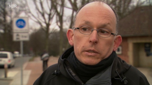
This street is optimally suitable for a cycle-street. It has little motor traffic, very little motor traffic, it has enough width. The cycleway was always too narrow, there was always conflict with people walking, and it works here, as anyone can see, cyclists are traveling amongst the drivers, it all works. On the road one can safely and comfortably travel, therefore it makes sense to put the cycle traffic there.

[Note that as he says this, behind him you can see someone choosing to ride on the footway rather than mix with motor vehicles on the “optimally suitable” road.]

The ADFC-Hamburg representative talks, while a person cycling in the background votes with their feet, choosing the footway instead of sharing the 'cycle street' with a car.

A person cycling in the background votes with their feet, choosing the footway instead of the motor-dominated cycle street, making Erwin Süselbeck look somewhat silly.


VOICE-OVER:

But while we were filming, several passing cyclists felt the need to stop and voice their concerns.


MAN IN GREY COAT:

Just this week, I’ve had three situations that were very close. You are lobbying for cycling, right? It’s a busy street, it’s no good for cycling.


ERWIN SÜSELBECK, ADFC HAMBURG:

That’s not correct, this road is optimally suitable for a cycle-street.


MAN IN GREY COAT:

When the drivers overtake at 30 miles per hour?


ERWIN SÜSELBECK, ADFC HAMBURG:

No, they shouldn’t drive that fast.


MAN IN GREY COAT:

But they do it anyway!


VOICE-OVER:

The city of Hamburg has spent around 20,000 Euros to rip out the old cycleway. But the cycle-street won’t be ready until at least 2017. So cyclists just have to use the road as it is.

Just what was the transport department thinking?


SUSANNE MEINECKE, HAMBURG TRANSPORT AUTHORITY:

We’re not forcing anybody. Cyclists are safe on the road here. And we want to offer something reasonable for cyclists, and the old cycleway wasn’t a reasonable offering.


VOICE OFF-CAMERA:

But you are forcing people, you’ve ripped out the cycleway already.


SUSANNE MEINECKE, HAMBURG TRANSPORT AUTHORITY:

Yes, but with that, we’re giving them a cycle-street.


VOICE OFF-CAMERA:

That nobody wants.


SUSANNE MEINECKE, HAMBURG TRANSPORT AUTHORITY:

[Long pause…] I honestly don’t understand your questions. There are very few people driving here, and cyclists are safe on the road. I don’t understand the problem.


VOICE-OVER:

Many citizens clearly see it differently.


MAN IN BROWN COAT:

You don’t travel here.


SUSANNE MEINECKE, HAMBURG TRANSPORT AUTHORITY:

How would you know?


MAN IN BROWN COAT:

Most people who cycle here laugh at your plans.


SUSANNE MEINECKE, HAMBURG TRANSPORT AUTHORITY:

That’s not true.


MAN IN BROWN COAT:

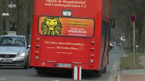
The people who do are in danger. Just look at the traffic. This type of vehicle [points at tourist bus] I’ve been endangered a few times myself. Look at this, they’re deadly dangerous. They travel along here one every minute, and they don’t care that it’s a cycle-street, or about the 20mph limit, or any such things. It’s deadly dangerous here.

A man talks to a Hamburg council representative, pointing to a tourist bus in the background, with which he is expected to 'share' the road.

“Look at this, they’re deadly dangerous.”


VOICE-OVER:

Many feel that instead of the controversial cycle-streets, they would prefer new cycleways to be built. Many roads in the city have none, and some of those that do exist are so bad that they barely deserve to be called cycleways.


MAN IN SILVER CYCLE HELMET:

I think it’s senseless planning. When there are so many potholes in Hamburg, frost damage, but there’s money for pointless stuff.


WOMAN IN BEIGE HAT:

I can’t believe that they’ve frittered away so much money – our money – on complete nonsense.


VOICE-OVER:

Even though the transport authorities may have meant well, for many cyclists this project has caused more problems than it has solved.


It makes me angry that some cycle campaigners continue to ignore the general public who repeatedly say time and time again that they don’t want to cycle amongst motor traffic.

Frau Meinecke may not understand the problem, but I can explain it to her easily: This debacle demonstrates the dangers of listening only to confident cyclists and ignoring the everyday users of cycling for transport.


9 Comments

Filed under Uncategorized

Picture-post: MORE terrible cycleways on York Road in Leeds

So in the previous instalment we headed west, from the Ring Road towards the city centre.

This time we’ll cross the road, turn around and head back eastwards to our starting point, but on the other side of the road.

The Superhighway begins here as a Superfootway, i.e. it used to be illegal to cycle here but the council have put up a sign so now it’s perfectly safe and OK.

What looks like a footway, but has been designated part of the Leeds-Bradford Cycle Superhighway, so now cycling is allowed here

The shared footway soon splits into a spearate cycleway and footway, and we then arrive at our first bus stop bypass:

A cycleway passes a bus stop but people walking are expected to cross cycleway twice, and both surfaces look the same

So if you’re on foot, you’re expected to look over your shoulder and cross the cycleway twice simply to walk straight on.

I assume the bin isn’t fixed, but the lamp-post and overhanging shrubbery – plus the sharp angles – make the cycleway feel uncomfortably narrow. There’s also little differentiation between the two, I imagine people getting off the bus will have no idea what all this means.

After the bus stop above, people walking are meant to leave the road (there’s a footpath on the left) and the old footway along York Road becomes a cycleway, though of course people will continue to walk here.

The next bus stop is a real doozy…

A narrow footway with bus stop has been converted into a shared-use footway/cycleway despite there being clearly too little space

I mean, come on, seriously? The photo above shows Leeds Cycle Superhighway in all its crapness. Imagine when there’s a few people waiting for a bus, perhaps someone with a pram or pushchair, or children playing around.

Utterly unacceptably poor. There’s no defence for this.

Here’s another bus stop further along, with added blind corner for extra thrills:

Another badly-designed bus stop bypass, this time with a dangerous blind corner

So people going to the bus stop will be coming from just behind that concrete wall, directly opposite the tactile paving you can see. A recipe for collisions (or it would be if more than a handful of people actually cycled in Leeds).

Later on, after more shared footway, we reach a junction which serves only a pet shop (and fire engine access):

Shared cycleway/footway crosses a minor side road, with confusing priority

The kerbing here is a mess, it doesn’t scream “give way to cycles” to me. I certainly wouldn’t trust cars coming off the main road to stop here, as the kerb line guides them smoothly around the corner.

I’m nothing if not fair, so here’s a photo of a bit that isn’t too bad:

A cycleway that isn't too bad, but has strange drainage undulations

It’s (fairly) clear, it’s free from obstructions, it’s a decent width, the drain covers are wheel-friendly. If it was all this good, I wouldn’t complain. But then, the straight bits should be simple to do!

Note how the right-hand side undulates, rising and falling where the drains are. Now I’m no drainage engineer, but shouldn’t this have been achieved with camber? I can’t say I’ve noticed cycleways elsewhere doing this, but perhaps there is a good reason for it (and this isn’t the case elsewhere). As least they’ve thought about drainage, a concept which seems to have escaped engineers elsewhere!

Another bus stop bypass now, which is ridiculously narrow given the width of the road here (almost 40 metres wide!):

Narrow cycleway past bus stop despite extremely wide road width

This is followed by a whole bunch of driveways to private business properties, each of which has been designed like to:

Driveways interrupt cycleway on York Road in Leeds

Does it look to you like the cycleway (or the footway) has priority over motor vehicles here?

Note also that, due to the smooth ride which King Motorist must receive, the cycleway undulates at each driveway (look at the kerb and you’ll see it). That’s not how to do it.

Nor is this:

Wide-radius junction for fast motor turning cuts across cycleway and footway, on York Road A64 in Leeds

Again, a cycleway junction this close to a 40mph road will never be safe. What’s odd is that elsewhere along the route, the space occupied by the old painted cycle lane has been taken, whereas here the entire new cycleway is within the old footway. Combine the old painted cycle lane with the space available on the left, and this junction could have easily been designed to be much safer and comfortable.

Instead yet again the protecting island ends too far back, the kerb line cuts across the cycleway and guides drivers smoothly around the corner at speed. No amount of paint will fix this. It needs redoing from scratch.

A little further on, the cycleway and footway are once more squeezed together at a bus stop, so that motor vehicles may pass unhindered:

Barely-used driveway interrupts cycleway/footway, after shared-use bus stop

And the driveway – for an electricity substation, so hardly a busy driveway – has visual priority over people walking and cycling.

Here’s a view from a footbridge, showing the narrow medieval route ahead:

Photo taken from footbridge over York Road in Leeds, facing east, looking over eight lanes for motor traffic (two of them bus lanes)

For a look back towards where we’ve just come from, click here.

Moving on, we’ll see how the old painted cycle lane is being taken away to provide more space for a cycleway:

Unfinished work on the Leeds Cycle Superhighway, with parked motor vehicles blocking the footway

I really don’t like the look of that junction though, and the plans show a mere painted cycle lane here (so not much different from what we see today).

The residents of this part of the road park their vehicles all over the footway, but formal parking spaces are being provided as part of the scheme, so I hope the cycleway and footway are kept clear of parked vehicles.

Further on – past more poor junctions and squeezed-in bus stops – we arrive at… shared-use footway and toucan crossings!

Cycleway and footway become shared-use at busy junction, with three separate crossing phases

Yes, this is how the Leeds Cycle Superhighway is treated at busy junctions. Legalised footway cycling and toucan bloody crossings. The very crap which has failed to do anything for cycling in the UK, but this time it’s Super.

Nothing says Cycle Superhighway quite like having to mix in a narrow space with people on foot, and wait at THREE separate signals just to go straight on across one side-road (it’s the access road to Asda, if you’re familiar with the area).

Truly dire.

Further up the hill at the next junction, the same treatment has been used:

A separate cycleway and footway turn into shared use area at junction with limited space

Once more, I ask: is there really enough space here? What if a family is waiting to cross the road to the right? This clearly is a bodge job, and not even nearly the best solution.

Moving on, we find that at an access driveway the cycleway disappears altogether:

Poor and dangerous cycleway design at service driveway, where motor vehicles appear to have priority

This is the access to the parking for a fire station (not the emergency fire engine exit). Given all the space available here, this is an awful design.

Next we come to what is probably my favourite section:

Insane junction design where cycleway and footway criss-cross each other multiple times

The design team were surely on some very strong drugs when this was drawn. It’s all a bizarre attempt to give access to the existing traffic island and toucan crossing on the left, without making any changes to the existing road layout.

From where I’m stood, the cycleway is on the left (coming towards the camera). I’ll let you trace the various paths yourself.

Turning around, we see that we’re back at the section where the cycleway is raised above the footway. This means that you’re now cycling on a long podium right next to fast-moving motor traffic. Don’t wobble!

Cycleway is a strange raised platform right alongside a busy 40mph road

Would it really have been so difficult to move the whole thing left by a couple of metres? That would have made all the difference. It’s just grass!

Another junction now, does it look like priorities are clear?

Very poorly designed junction of cycleway, footway and side road, with vague priority and mess of white paint

That’s a minor side road sweeping across both the footway and cycleway there. People will be cycling towards the camera (in theory, anyway) and will have to watch for cars approaching from three directions.

We’ve almost finished our safari now, just a few more things to see…

Here we have another side road with wide, sweeping junction, which is dangerously designed despite the amount of space available. (This is where the old York Road heads left, and is a popular rat-run.)

A car turns off the 40mph York Road directly into the path of the cycleway

Followed by the entrance/exit to a supermarket car park:

Car park entrance/exit with motor priority over walking and cycling

And finally, a shrug of the shoulders at a toucan crossing. I’m becoming numbed to this rubbish now.

Cycleway and footway merge at pedestrian crossing to form shared use footway

And that ends our walk along the eastern section of Leeds’ so-called “Cycle Superhighway”. I hope you’ve all enjoyed yourselves, and please – don’t have nightmares.

If anyone would like to see the whole 130-odd photographs I took, get in touch and I’ll make them available somehow.


Coming soon! The Superhighway in the West (of Leeds).


13 Comments

Filed under Uncategorized

Picture-post: Terrible cycle infrastructure on York Road in Leeds

I’ve covered the dreadful design and execution of the Leeds-Bradford “Cycle Superhighway” before, but I’ve never had chance to get a good look at it up close, relying instead on reports and photographs from concerned readers.

However, recently I got a chance to take a detailed look for myself, and unfortunately, even with the low expectations I had, I was disappointed. For the money spent, disruption caused, and time taken, this could have been great, but it’s rubbish.

No doubt the propagandists responsible for defending this shambles will once more repeat their favourite phrase, “it’s not finished yet,” as mitigation for the poor design you’re about to see. But a lot of the roadworks are finished, and some paint and a few signs aren’t going to make much difference.

So join me, if you will, for a stroll along the A64 York Road, Leeds’ main east-bound traffic artery, signed for a 40mph limit which is often ignored. We’ll laugh, we’ll cry, we’ll shake our heads sadly. My dear readers, I present to you, Leeds Cycle Superhighway…


We’ll start at the eastern point of the scheme, next to the Ring Road, and head west into town. I’ve not included photos of every inch, but I’ve tried to give a sense of what’s been installed here (the junctions I’ve missed out aren’t much different to the ones I’ve included).

Firstly we can see that the definition of both the cycleway and footway disappear at every driveway for some reason, presumably because today’s motor vehicles couldn’t possibly mount a small kerb, right? (Though prams and wheelchairs clearly can…)

Clear cycleway priority over people walking, but driveways get smooth treatment without kerbs

What this will probably mean in practice is that drivers will continue to treat the cycleway as part of their driveway, and park their cars there. Why was red asphalt not used? Why is the kerb line interrupted? There’s no need for this, it should be better.

For some reason, beyond the junction the cycleway is raised up above the footway (i.e. the opposite to what you’d expect, and not what was promised by City Connect).

Soon the cycleway disappears altogether, and turns into shared-use footway, despite York Road being over 35 metres wide at this point.

Separate footway and cycleway end, turns in to shared footway. A car is parked on the footway in the distance, blocking it.

Note the car parked on the Superhighway/shared-use-footway in the distance, and the nearer cars parked on the footway too. (I’m told enforcement is due to start next month.)

After the parked car, the shared footway becomes a separate cycleway and footway again, but note what you’re expected to do if you’re walking straight on (the footway is on the left, by the way).

Shared footway ends, but people walking must cross the cycleway, which is on a raised platform

Yes, people on foot are expected to continue along the ever-decreasing footway, then cross the cycleway. (From this point on, the cycleway is a raised platform above the footway – you can see the hump just after the crossing in the photo above.)

Then, once you’ve walked past the bus stop, you’re expected to… cross again!

A strange raised cycleway, with a bus stop and foot crossing in the distance

This is a recurring theme – the cycleway and the footway cross each other constantly, which introduces unnecessary conflict, indirectness and delay. Of course, in reality, people will just walk along the cycleway here.

Next we come to the junction with Cross Gates Lane, which is a huge junction for what should be a residential street. The speed table and give-way markings are undermined by the kerb line and the double yellows, which both interrupt the visual priority of the cycleway.

A wide junction, with cars approaching from three directions, all of which appear to have priority over walking and cycling, thanks to poor design

The footway is also severed here, which makes it look even more like people driving have priority. To add to the danger, motor vehicles can approach from three directions, as there is a turning gap in the median along York Road.

Soon we arrive at a service road which runs alongside York Road but is for local traffic only. You might think that using the service road would make sense here, as surely it’s quiet enough?

People walking must cross yet again, and not use the cycleway which is much more convenient

Nope, instead we’ll re-route people walking across the road (again!) onto a narrow footway, then designate the existing footway as the Cycle Superhighway, put up some ‘no parking’ signs, job done.

Sign says 'no motor vehicle parking or loading on footway or cycle track'

The message is clear, at least. But will it be heeded?

At the bottom of the hill there is a petrol station, and here is how the crossover is handled:

A cycleway and footway cross the entrance to a petrol station, which disrupts them both

I crossed from the other side of the road to take the above photo, and I found I had no idea which side was footway and which was cycleway. I later deduced that the raised section (on the left) is the cycleway, and the footway is the bit with the road sign and advertisement blocking it.

Around the corner, after some more shared-use footway, we reach this ancient relic of an earlier attempt at cycling infrastructure.

Old cycleway and shared use area in Leeds, perhaps from the 1990s, in poor state of repair

So Leeds City Council are still installing the same bad infrastructure that they were back when this was fresh. It’s almost as if they want to suppress cycling…

Further along still, we find a long section on which work hasn’t even begun. I’ve been told that the route will open in Spring – I’m assuming that means Spring 2016 – but that’s clearly not going to happen.

I’m not even sure where the cycleway could go here, given that at no point so far has any space – not even one lousy millimetre – been taken from motor vehicles. More shared-use, perhaps? Or an on-road painted lane?

Very narrow footway with motorway-style barrier on A64 York Road in Leeds

Moving on, and we eventually arrive at a footbridge which crosses York Road, giving us this panoramic view of the narrow, medieval streets into which decent cycling infrastructure simply won’t fit.

Photograph taken on footbridge over York Road in Leeds, facing west, looking over six lanes for motor traffic

Again, note that work hasn’t even begun on the westbound section. It’s not looking good for a Spring 2016 opening.

Incidentally, even though the walk from end to end would take about an hour, it took me about double that, as I was stopping to take photos and switch sides. In those two hours I saw three people cycling – two children messing about, and one adult actually using a bike to get somewhere.

In that same time I must have been passed by many thousands of motor vehicles. You can do the maths yourself to estimate the modal share on this particular Saturday afternoon.

To prove that Leeds’ lone transport cyclist wasn’t a figment of my imagination, here is documentary evidence of this rebel, who helps to give some scale to the dreadful bus stop bypass:

A cyclist uses a narrow, badly-designed bus stop bypass

Three lanes of motor traffic and still the bus stops in a lay-by, meaning walking and cycling both suffer.

I don’t remember where he went next, but I hope he looked over his shoulder very carefully:

A shallow-angled slip-road, designed for turning off a fast road without slowing down much, cuts across a footway and cycleway

Yes, that’s a slip-road which exits off a 40mph main road and crosses the cycleway and footway at an oblique angle. The cycleway is apparently going to have priority over turning motor vehicles here.

This clearly isn’t safe. How do these so-called engineers sleep at night?

Just beyond that mess we reach another service road, which should be an open goal, right? Again, no:

Cycleway squeezed up against fast road, instead of using service road alongside

It’s still under construction, but that will be the cycleway on the right, squeezed up alongside a fast, busy road. Surely that space would have been better used as car parking, with cycling sharing the service road?

Finally on this wastbound run, we reach the extent of the current works, at the very edge of Leeds city centre, just after this masterful work…

Narrow cycleway and footway alongside three wide lanes for motor traffic


That’ll do for this post, there’s only so much you can take in one sitting. Once you’ve steadied your nerves, we can take the trip in the other direction, heading out from town back east towards the Ring Road. If anything, it’s even worse.


32 Comments

Filed under Uncategorized

More broken promises on Leeds’ so-called “Cycle Superhighway”

After the anger surrounding the dangerous new junction at Grange Avenue in Bradford, another kind reader has sent me photos of shockingly poor design on the brand new Leeds-Bradford “Cycle Superhighway”.

This time, the junction is at the A647 Stanningley Road (a busy motorway-esque road with a 40mph speed limit) and Houghley Lane (a residential street with some, but not much, rat-run potential). Here’s a link to the location on Google Maps, the junction in question is the one on the north (eastbound) side of Stanningley Road.

Like last time, the original plans released by City Connect clearly show a junction with priority for those cycling across the minor road:

A section of released plans for the junction of Stanningley Road and Houghton Lane in Leeds, clearly showing an unbroken painted cycle lane across the junction mouth.

Although it’s a very poor design, there is at least clear priority for people cycling across the junction. The original PDF is here.

Never mind that the design – used frequently in the Leeds-Bradford plans – shows the kind of junction at which cyclists are returned to the carriageway, meaning this won’t be attractive to people who currently don’t cycle.

Never mind that this is exactly the kind of junction design despised by German cycle campaigners for its role in many cycling deaths and injuries.

Never mind that this junction is where Kate Furneaux was killed in 2009 by rat-running lorry driver Peter McCurry. And never mind that the new design shown above offers no protection or benefit over the painted cycle lane that Kate Furneaux was using.

Never mind that the junction could easily be removed entirely, eliminating the danger altogether. Residents could instead use the signalled junction at Cockshott Lane, adding a mere 0.1 miles to their journey.

Never mind that Stanningley Road is over 30 metres wide at this location, with a huge grassy median and turning area, providing plenty of space which could be used for a top-class junction design.

So never mind all that information, which tells us that several far superior solutions were possible, desirable and necessary.

Let’s take a look at what has been installed:

A cycleway and footway next to a busy road, with a junction just beyond. The cycleway suddenly ends, the footway becomes shared use for walking and cycling, and metal barriers appear.

This doesn’t look continuous to me. And it certainly ain’t “super”.

I’m told that a safety audit flagged up the death of Kate Furneaux, and suggested that a painted cycle lane wasn’t safe here. It should have been clear from the start that this junction needed genuine improvements. Why must it come to a safety audit before anyone realises that painted cycle lanes are no good? Any cycle campaigner could have told them that years ago.

So I can see why the original plans were changed – but the delivered design is a terrible solution that does little to address the danger. There is so much wrong with it, it might even be worse than what was planned.

People riding along the cycleway are expected to join the footway, turn left, turn right, then cross the side road (without priority) as if on foot. At the other side, they’re expected to perform the same manoeuvre in reverse to join the next section of cycleway (which is being used as a parking bay in the photo above) just before a busy driveway cuts across it.

To add insult to injury, there’s two grates and wheel-grabbing tactile slabs just as you’re expected to make the left turn.

Unsurprisingly, many people are choosing to leave the cycleway at this point, and rejoin the carriageway – as is evidenced by the many tyre tracks in the mud. No doubt this will cause aggravation as drivers believe “cyclists don’t even use the perfectly good cycle lane provided.” This stuff doesn’t please those who already cycle, and it won’t entice many to begin cycling either.

The City Connect scheme was an opportunity to reconfigure the road to provide real cycling infrastructure, safe and suitable for all. Instead we’re left with another broken promise, another dangerous junction, another useless piece of pretend infrastructure squeezed into a tiny slice of land between the footway and a dangerous road.


Before publishing this blog post, I asked City Connect if they’d like to comment, and received the following:

“The design was altered following concerns raised through the safety audit. The concerns are around the junction layout and a cyclist fatality at this junction. In addition to this, the time and budget constraints on this project mean that we are unable to change the junction to a more desirable line due to 3rd party land constraints. Given that this scheme is the first one that’s sought to create a predominantly segregated cycle route, and the current cycle lane is on highway, it would not meet our aspirations to leave as is.

We are committed to reviewing the operation of these facilities and, if necessary, make any alterations, subject to funding availability. We are also reviewing the pedestrian guard rail at this point and the proximity and positioning of it in relation to the cycle track and there is also a speed table to be installed. We recognized concerns raised by local cyclists and are addressing them through the programme resource. It’s not yet finished and the consultation and review process for the whole scheme is continuing.”

I’m grateful for the swift reply, but I’m not convinced by any of the points raised. The safety audit rightly recognised the lack of protection offered by paint, but the chosen ‘solution’ is clearly encouraging many cyclists to use the carriageway, negating any benefits which a cycleway might bring.

While I accept that City Connect may well be “committed to reviewing” this farcility, it’s clear that the money has been spent and it’s pretty much going to remain like this for a long time. Enjoy using your Superhighway, folks.

As Leeds has just been outed as one of the worst UK cities for air pollution (air pollution costs Leeds £480m anually, and obesity costs £304m) you might expect the council to enable active transport, yet instead we merely get half-baked infrastructure and more hot air in the form of weak excuses.

Leeds may well have been the Motorway City of the Seventies, but it’s now Car-Choked City of the 2000s – and the council is doing everything they can to make sure it remains that way for a long time.


Does anyone have any genuinely good examples of infrastructure from this project worth sharing? Get in touch if so.

19 Comments

Filed under Uncategorized